This post originally appeared on PhillyH2o in May 2003, and was revised in October 2009. It is a narrative version condensed from the historical timeline also posted on WaterHistoryPHL.


OVERVIEW
Frankford Creek watershed has two major tributaries: Tacony or Tookany Creek (with its source in Montgomery County) and Wingohocking Creek (which was completely encapsulated in sewers between 1879 and 1928). This section of this watershed within the Philadelphia city limits is typical of many watersheds in urban areas. In the course the past 300 years, the Frankford Creek watershed has been subjected to:
- Increased sediment loads from removal of woodland, probably early in the city’s history;
- Construction of dams for mill ponds and diversion of water through races to provide power and process water for industry;
- Encroachment on the flood plain, and sometimes on the stream channel itself, from the structures associated with these industries;
- Direct pollution from these industries;
- Direct pollution from residential sewage;
- Complete encapsulation of three major tributaries to provide drainage and sewerage and to open up otherwise inaccessible valleys to real estate development;
- Indirect pollution from runoff as impervious surfaces increased during intensive residential development in the 20th century;
- Increasingly severe storm flooding and stream erosion; and
- Major channel alterations in the lower reaches of the watershed, both to facilitate urban development and to relieve flooding.
On the positive side, hundreds of acres in the northern section of the watershed in Philadelphia were set aside as parkland in the early 20th century, which certainly helped prevent further degradation of environmental quality. Unfortunately, by the time the parks were created (Juniata Park in 1889 and Tacony Creek Park in 1908), either the damage had already been done, or the wheels of progress that led to the circumstances requiring the channelization of the lower stream reaches had already been set in irreversible motion.
EARLY HISTORY AND INDUSTRY
It is safe to assume that by 1820 or earlier, the majority of the woodland in the watershed had been cut down, due to both the need for the wood as fuel and construction material, and to open up new land for agriculture. Such changes are difficult to document, but this likely increased sediment loads in the streams.
Early industrialists built in the flood plains of the main streams and the tributaries, their mills sometimes encroaching directly on the stream channels. They further altered the flows by building dams that backed up water in large ponds. Mill races were dug to carry water from the ponds to the factories, where it was used to power machinery as well as for industrial processes, such as bleaching and dyeing. So-called “tail races” carried this used process water, often laden with chemicals, back into the streams.
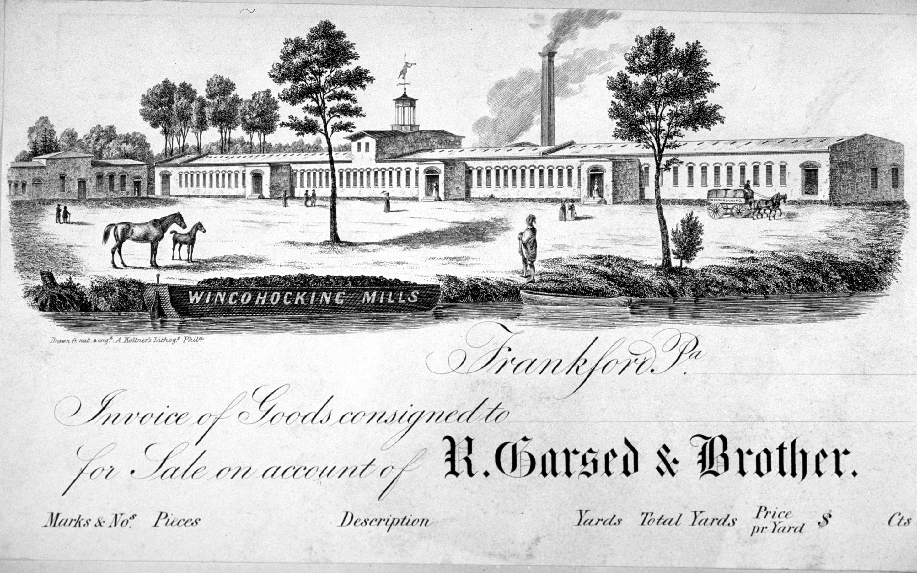
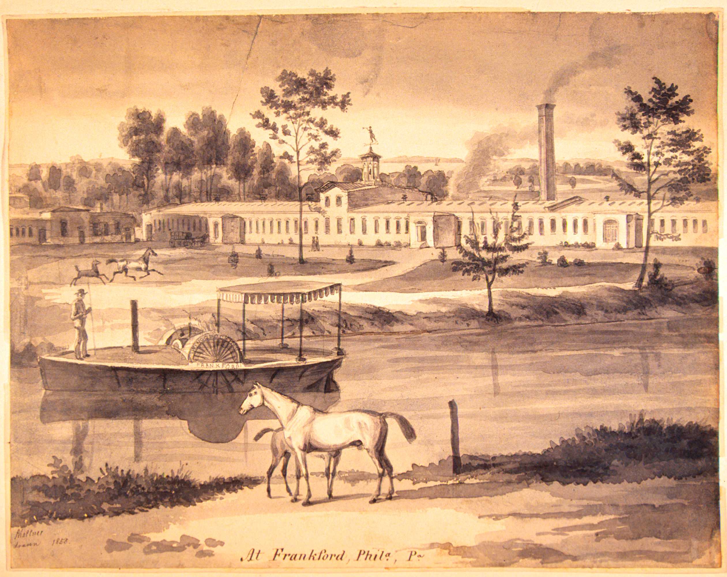
The billhead for R. Garsed & Brother, in Frankford Pa., shows the company’s Wingohocking Mills, a textile factory located along Frankford Creek at Ashland Street, just downstream of the mouth of Little Tacony Creek. The fine print to the bottom left of the image reads: “Drawn fr[om] nat[ure] & eng[rave]d A. Kollner’s Lithog[raph]y, Phila.” The drawing “from nature,” by August Kollner, is shown below. The drawing is dated 1853, which is probably also the date of the billhead. Both items are from the Castner Scrapbooks of the Free Library of Philadelphia Print and Picture Collection. The Free Library’s Map Collection also has a copy of a Hexamer General Survey of Wingohocking Mills from 1866.
Philadelphia became world-renowned for its textile production in the 19th century, and Frankford Creek and its tributaries had a concentration of this industry. An 1849 map that encompasses only part of the watershed includes more than 30 factories, about half of them related to some aspect of textile work. Expansion of textiles and other industries in the watershed continued through the 19th and early 20th centuries, increasing the pollution load in the streams.
SEWAGE POLLUTION AND STREAM ENCAPSULATION
Following standard practice for sewer design in the 19th and early 20th century, sewers serving built-up areas dumped their wastes directly into the nearest stream. In the Frankford watershed, this continued until at least 1930s in some sections, and had the effect of making “open sewers” out of these streams. Instead of providing alternate channels for the sewage in so-called “interceptor sewers,” City engineers decided to turn three major tributaries into combined sewers: Wingohocking Creek, which drained most of Germantown and Mount Airy; Little Tacony Creek, which had an extensive watershed northeast of Frankford; and Rock Run, which ran though the present sections of Olney and Fern Rock.

These three streams, in projects that began in the late 1870s and continued through the 1930s, were completely obliterated from all but the City’s sewer maps. Once the streams were put into pipes, their valleys were leveled (more than 40 feet of fill was used along some sections of the Wingohocking). Streets were laid on top of this fill, and water and gas mains were installed, providing landowners with a ready-made infrastructure that sped up the sale of their house lots. The tax revenues provided by the new real-estate in these quickly-growing neighborhoods sometimes paid for the cost of these massive creek-to-sewer projects within as little as five years.
While these projects alleviated the problem of sewer-laden creeks running through developing neighborhoods, the new sewers simply moved the problem further downstream, as they emptied their raw wastes into the Tacony and Frankford Creeks. It was not until the 1923 that the sewage-laden flow of the Wingohocking was diverted from Frankford Creek into an interceptor that carried it to the newly-constructed Northeast Sewage Treatment Works. Unfortunately, other interceptors were delayed by the Great Depression, and sewage continued to flow into the Frankford Creek through the 1930s and beyond. It was not until the Northeast plant was completely revamped in the early 1950s, and the interceptor system completed in the 1960s, that the City stopped polluting its streams and rivers with raw sewage. See From Creek to Sewer for more information on stream encapsulation and sewer development.
JURISDICTION OVER THE LOWER FRANKFORD
In 1799 the Pennsylvania legislature declared that Frankford Creek, from the mouth to about where Frankford Avenue crosses today, was a navigable stream. This meant that a channel deep enough for the use of small craft and barges had to be maintained, and that drawbridges had to be provided for any stream crossings in that stretch. The “navigable” designation put the jurisdiction over the creek in the hands of the U.S. War Department (specifically, the Army Corps of Engineers), which seriously hampered the City’s ability to maintain the channel for either navigation or flood control.
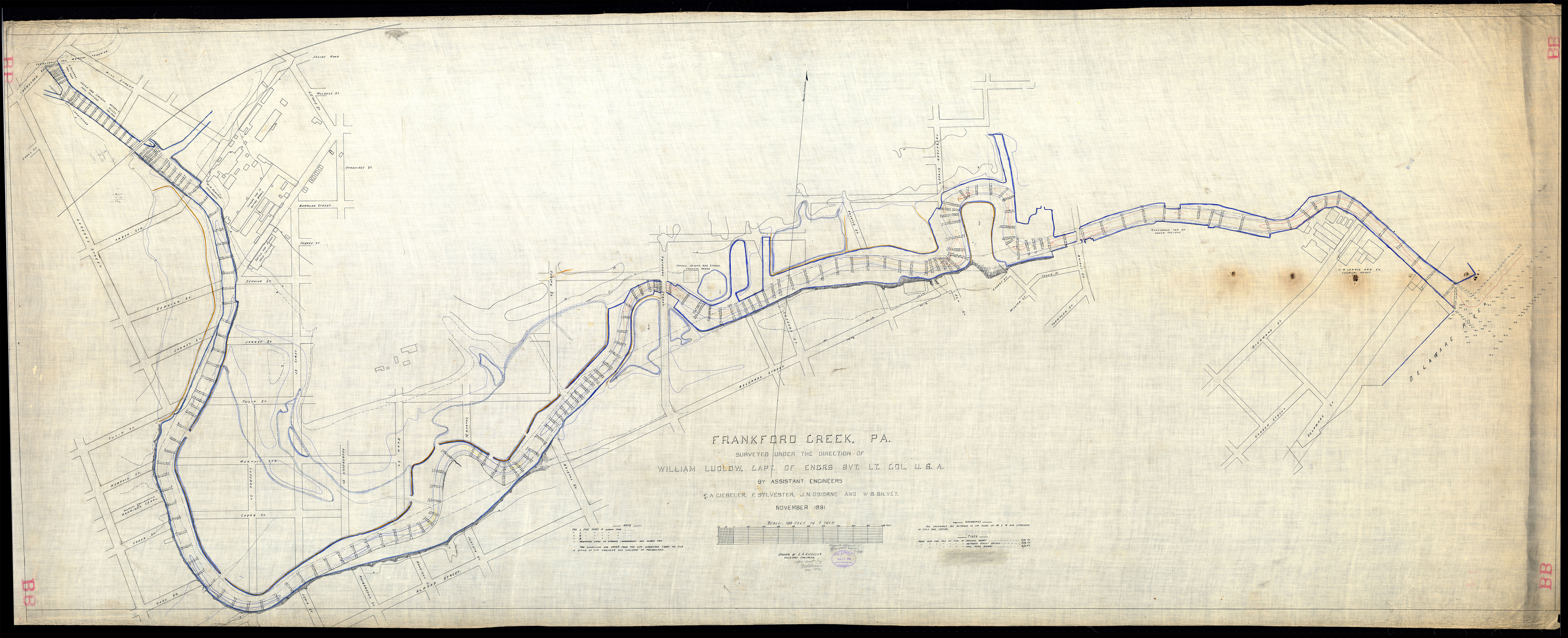
From the 1884 on, the City made repeated requests to have the channel dredged, all of which the War Department turned down. The City itself dredged the parts of the channel several times, but by 1929 it was basically unusable for navigation. A 1931 City engineering plan for flood control in the watershed stated that the creek’s “condition is such that it can be used only by small boats at advantageous stages of the tide.” Photographs from the period reveal that at low tide, mud flats were exposed for much of the supposedly “navigable” stretch. A 1932 report from a City sanitary engineer further expounded on the condition of this mud: past Duncan Street, the inspector stated, the waters of the creek “are almost black, foul smelling and greasy, and at low tide heavy deposits of slimy mud are visible.”
The cost of the dredging and bulkheading called for in 1931 plan was estimated at $2 million, but during the Great Depression the City had no funds available for this or many other badly-needed projects. In 1938 the War Department again refused to deal with the problem, but by 1940 pressure from local congressmen finally resulted in the relinquishing of Federal control over the creek. A similar move by the Pennsylvania legislature in 1941, relinquishing any state control, finally gave the city jurisdiction to implement its own flood control plan. But with the outbreak of World War II these plans, along with most public works projects, were again put on hold.
FLOODING AND FLOOD CONTROL
The Tacony-Frankford watershed was probably prone to flash floods even before its lands were developed, since the upper part of the stream runs in a steep valley, dropping about 400 feet in its run from Montgomery County through Philadelphia to the Delaware River. But these floods certainly became more frequent and sudden in the 20th century, as the upstream areas began to be developed into residential neighborhoods (encouraged by the creek-to-sewer projects described above). This intensive row house development greatly increased the amount of impervious surface in the watershed. By 1931, of the 15,500 acres of the watershed within the Philadelphia, 6,700 acres were fully developed, 5,500 acres partially developed, with the remaining 2,300 acres either unimproved or set aside as parkland. Converting the tributary streams into sewers also served to convey stormwater to the creek much more quickly, further intensifying the peak levels of flash floods.
More than a dozen major floods affected the lower part of the watershed, from Juniata Park downstream, from the 1920s through the middle of the 1940s. Floods were also frequent in the Logan neighborhood, in the valley of the former Wingohocking Creek, where sewers proved inadequate to the task of carrying off waters during heavy rains.
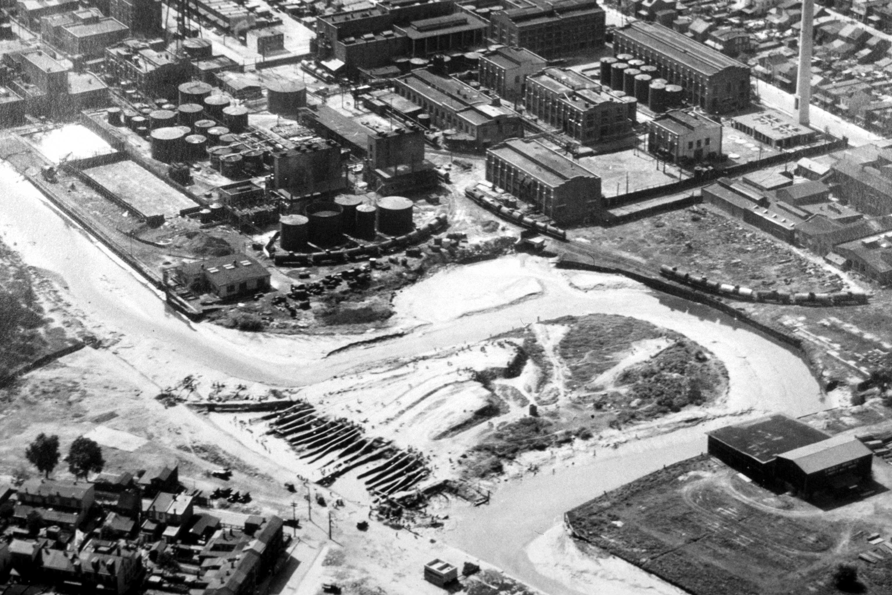
In Frankford, the problem was exacerbated by the removal of several dams, after which years worth of ponded-up silt washed downstream and clogged the channel; by the deposition of solid wastes from sewers and industrial discharges; and by numerous narrow, low-slung bridges, which constricted the flow in flood stage. Individual property built levees to protect their buildings, but with no coordinated plan these structures, if they worked at all, tended only to divert the problem downstream. Adding to the problem was the tortuous route of the stream’s lower reaches, with wide horseshoe-like meanders typical of a creek in the flatlands of the coastal plain.
The City’s 1931 flood control plan found that the existing channel of Frankford Creek could only accommodate a flow of 2,300 cubic feet per second (cfs), while storm flows were commonly measured at 5,000 cfs and, with future development, were estimated to possibly reach as high as 10,000 cfs. Since many factories were located in the flood plain (or, as already mentioned, in the creek channel itself) damage from the frequent floods added up to hundreds of thousands of dollars by the mid-1930s. Under the umbrella of the Northeast Philadelphia Chamber of Commerce, local industrialists lobbied for improvements in the creek to reduce the frequency of flooding. No comprehensive plan was possible due to the lack of funds, but token efforts were undertaken. A pick-and-shovel-and-wheelbarrow project, paid for by the Federal Works Progress Administration, employed more than 1,000 men to cut a new channel through a constricting horseshoe bend in the creek just above Bridge Street. At the request of several business owners, junked cars and other trash was removed from the creek a few times in the mid-1930s. But these piecemeal projects did little to alleviate the stream’s frequent propensity to overflow its banks.
Not until the City regained jurisdiction over the creek in 1941 (see “Jurisdiction…” above) could any comprehensive plan be implemented, and then the curtailment of most public works during World War II set the plans back again.
Finally, in 1947, the Frankford Creek Flood Control Project began, based on a report from Knappen Engineering Co. of New York City. The first step was to create a concrete cut-off channel across a constricting horseshoe bend south of Juniata Park, with a dammed “stilling basin” above this point to settle out sediment in times of high flow. Work on the concrete channel continued downstream over the next several years, with the creek boxed in completely through one stretch near Leiper Street. In the final phase of the project, completed in 1956, the creek’s flow was diverted into a channel that went straight to the Delaware, bypassing the long bend in the natural course that had carried it through Bridesburg and past the Frankford Arsenal. While the original mouth of the creek still remains, after the construction of a new storm sewer and a new intercepting sewer in the old bed, most of the channel above Bridge Street was filled in.
CHANNEL CHANGES UNRELATED TO FLOOD CONTROL WORK
In 1902, between Kensington Avenue and Frankford Avenue, the channel was moved about 400 feet to the west to accommodate changes in the city plan, including the creation of Torresdale Avenue.
About 1907, below the main line of the Pennsylvania Railroad, about 2,500 feet of channel was relocated, to avoid constructing a bridge for the Pennsylvania-Reading Seashore Lines leading to New Jersey. The new railroad embankment adversely affected flooding conditions, by blocking part of the natural valley that had been available for the accommodation of peak flood discharges.
Around 1910, to make room for the extension of Adams Avenue between Leiper and Church Streets, the channel was moved 100 feet to the east, and the old channel was filled in to accommodate the new section of Adams Avenue.