Excerpts from Report on Flood Control, Frankford Creek, City of Philadelphia, Pennsylvania. Knappen Engineering Company, October 1947
Besides providing a long range plan for the channelization of Frankford Creek (which was completed in 1956), this report offers the historical information excerpted below. I created these excerpts for the old PhillyH2o site in 2005, before I was able to scan the entire report (which is linked below). But while readers may prefer to read this information directly from the report, I still think it is worth presenting here in this form, since text on a website text is much more visible and searchable than text within a PDF.
While this was not a “creek to sewer” project in the sense of so many other streams in the city, which were buried out of sight in pipes, the work undertaken as a result of this report did turn Frankford Creek into a giant open channel with the aim of getting stormwater through the neighborhood and out into the Deaware River as quickly as possible.
This excerpt includes the following sections of the report
- Frankford Creek: Previous Investigations (pages 5-8)
- Frankford Creek: History of Flooding (pages 18-23)
- Frankford Creek: Previous Projects for Improvements (pages 27-31)
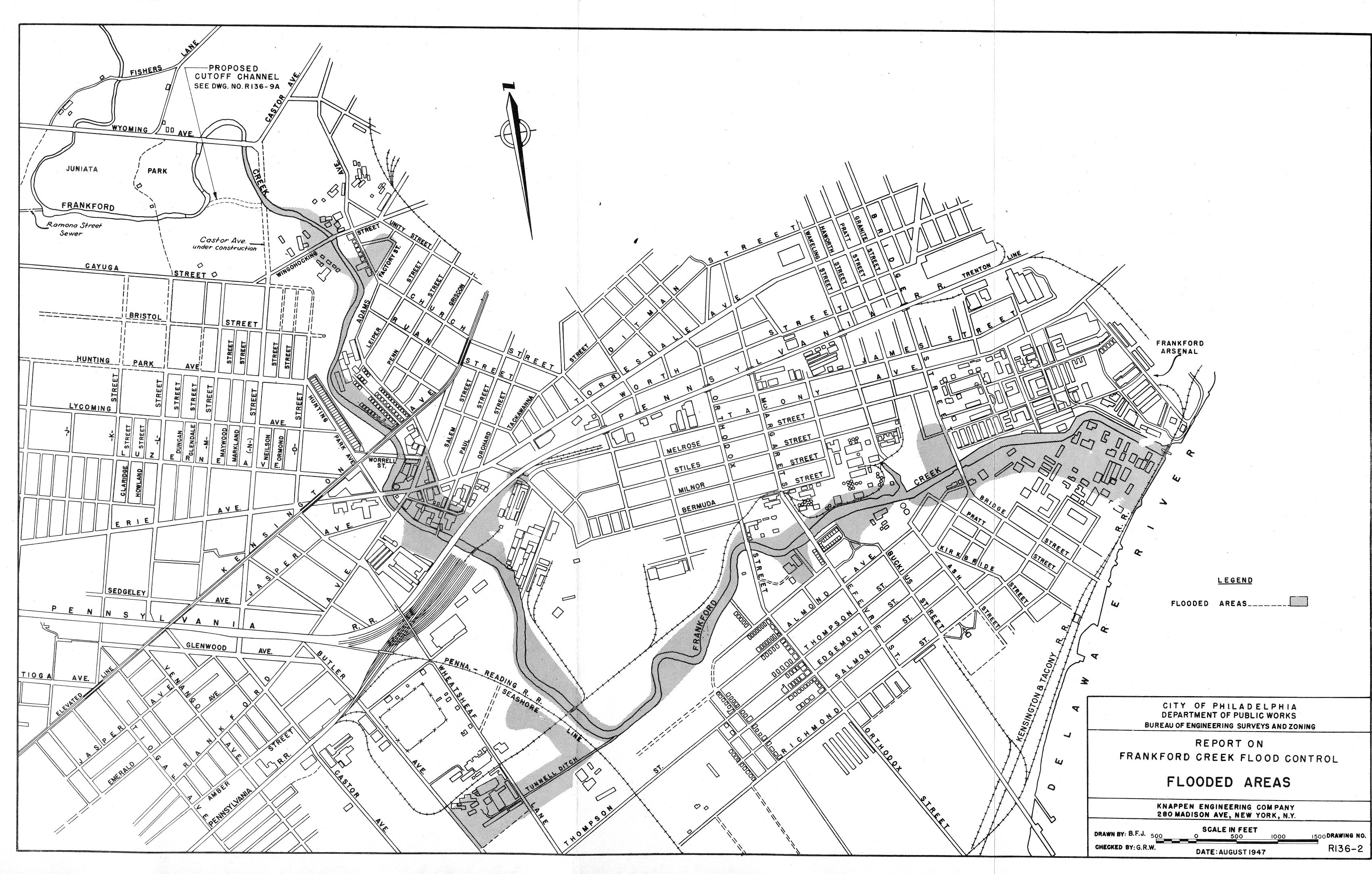
Click the cover below to read or download a PDF of the entire report, which includes dozens of photographs, plans and maps, a few of which are referenced in the following excerpts but are not reproduced here.
FRANKFORD CREEK: PREVIOUS INVESTIGATIONS
REPORTS BY THE CITY
The need for providing an adequate channel for Frankford Creek has been recognized for more than 60 years. Channel lines for the creek were established and confirmed upon the City plan as far back as 1885. Records show that these early lines were revised seven times in the period 1885 to 1902. Subsequent to 1902 attention appears to have been centered on the navigable portions between the mouth and Margaret Street. Surveys leading to dredging operations were made by the Department of Wharves, Docks and Ferries ten times in the period 1915-29.
A series of severe floods in 1931 again centered attention on the upper reaches of the creek. In that year the Bureau of Engineering made hydraulic studies of the channel capacity and re-examined the confirmed channel lines. A repetition of flooding in 1932 and 1933 resulted in suits against [page 6] the City to recover damages from frequent flooding. The City’s engineers made studies of the floods and the extraordinary storms causing them and these studies were presented as expert testimony in the court sessions in September 1932 and June 1933.

The current phase of the flood investigations on Frankford Creek stems from an Ordinance of Council approved August 9, 1944, the purpose of which was “to authorize a revision of the City Plan so as to establish thereon a right-of-way for the channelization of Frankford Creek as a measure of flood control…”. One of the provisions of this ordinance directed the Department of Public Works and the City Solicitor’s Office to make a joint report on the project. The report was prepared and submitted to the City Council under date of February 8, 1945. This report gave a brief description of physical conditions along the creek, stressed legal problems involved in obtained rights-of-way and made brief engineering recommendations.
REPORTS BY THE WAR DEPARTMENT
A preliminary examination and survey relative to the improvement of Frankford Creek for navigation was authorized by the River and Harbor Act of March 3, 1881. A favorable report was submitted by the War Department on January 25, 1882. This report, which was included in the Annual Report of the Chief of Engineers for 1882, recommended improvement for navigation from the mouth of the creek to Frankford Avenue at an estimated cost of $40,000. The project was adopted by the River and Harbor Act of August 2, 1882, and the sum of $10,000 was appropriated for a portion of the work.
In 1884 the Chief of Engineers reported that Frankford Creek was being regulated by the City of Philadelphia. and recommended that no further appropriation be made by the Federal Government. [page 7] The River and Harbor Act of August 17, 1894, provided the sum of $2,000 for straightening Frankford Creek in the vicinity of Aramingo Avenue. The District Engineer for the War Department reported that the proposed work had never been considered and was not justified by the prospective commerce. The work was never carried out by the Federal Government but was later undertaken by private interests.
A preliminary examination and survey was authorized by the River and Harbor Act of June 25, 1910. Pursuant to the authorization a report was submitted by the Chief of Engineers on November 7, 1912, and printed in 1913 as House Document No. 1260, 62nd Congress, 3d Session. It is interesting to note that this report found the actual and prospective commerce on the creek sufficient to justify improvement for navigation but that the Federal Government was not justified in undertaking the work because the benefits accrued only to the industries of Philadelphia.
The Committee on Rivers and Harbors of the House of Representatives directed on January 29, 1934, a review of the unfavorable report of 1913. The Chief of Engineers submitted a report on December 24, 1934, which was also unfavorable as regards improvements for navigation.
The final report by the War Department was authorized by Section 6 of the Flood Control Act approved June 28, 1938. This report, which was dated February 15, 1939, was a preliminary examination of flood conditions on that portion of the Frankford Creek watershed located in Philadelphia County. The conclusions of the report were that improvement for flood control or for flood control in conjunction with navigation was not economically justified. It should be emphasized that the authority for this survey only required comparison of past flood damages and probable future flood control and navigation benefits, and did not permit consideration of civic benefits to be [page 8] obtained from the reconstruction of obsolete bridges, from the correction of obnoxious and unsightly conditions, from the large potential increase in land and property valuations resulting from flood protection, and of the need for an adequate outlet for storm drainage.
The last action by Congress affecting Frankford Creek was taken on June 11, 1940, when an act was passed declaring the creek to be non-navigable within the meaning of the Constitution and laws of the United States. By that time the creek was non-navigable in fact due to filling in of the channel.
FRANKFORD CREEK: HISTORY OF FLOODING
EARLY FLOODS
With steep narrow valleys and a drop in elevation of 400 feet from the headwaters to the mouth, it is probable that Frankford Creek was always subject to sudden flash floods. Early reports indicate this to be the case. The 1882 report of the Chief of Engineers, U. S. Army, has already been quoted with regard to damage by “the bursting of dams”.
The same source in 1884 mentioned that the creek was subject to sudden and violent floods. The report published in 1913 as House Document 1260, 62nd Congress, 3d Session, states that “the creek is subject to floods of considerable height at and above the head of navigation.”
For this report more definite information has been pieced together from records of the Bureau of Engineering of the City of Philadelphia, from newspaper accounts of flood damage and from high water marks and other records preserved by property owners along the creek. The earliest flood for which there is a definite date was on September 15, 1904. No flood heights have been preserved for the flood, but rainfall records indicate that perhaps it was greater than any flood of recent years. Residents along the edge of Juniata Park recall a damaging flood in 1906, probably in June, which ruined the gardens of a nursery at Fisher’s Lane. Floods of sufficient importance to be mentioned in records occurred on August 9, 1916, and August 12, 1918.
RECENT FLOODS
The first flood for which we have found a known elevation is that of July 23, 1927. Newspaper accounts say that it was the greatest flood in the previous ten years. From records of flood heights, it has been determined that the 1927 flood was exceeded at least 10 times in the subsequent 20 year period, indicating an abrupt increase in flood frequency in recent years.
Property owners along the creek were inconvenienced by floods from time to time prior to 1930, but beginning with the flood of June 26, 1930, they experienced a long series of disastrous inundations. In the summer of 1931 there were record breaking floods on July 10, July 14 and August 10. Floodmarks are available only for the flood of July 14. That flood had an estimated discharge of 6,500 cubic feet per second, and is quite certainly the greatest flood in the past 30 years.
The second largest flood came on August 18, 1932, with a discharge of 5,800 cubic feet per second. In the 17 year period 1930-46, inclusive, only the three years 1940, 1942 and 1944 appear to have passed without flood damage. Because there has been no continuous record of the variations in stage of the creek, there may be some omissions in the record as pieced together but the following chronological list of flood rises is believed to be quite complete (newspaper articles, where available, are linked):
- 1882: September 25 (added by Adam Levine)
- 1927: July 23
- 1929: Sept. 8
- 1930: June 26
- 1931: July 10, July 14 (Bulletin and Inquirer), Aug. 10, 1931
- 1932: March 28, July 22, Aug. 18
- 1932: November 1 (added by Adam Levine)
- 1933: May 24, Aug. 23
- 1935: June 30, July 9, Sept. 6
- 1936: Jan. 9
- 1943: Floods in May, June, July and October
- 1937: Aug. 26
- 1938: July 23, Sept. 23
- 1938: August 18 (added by Adam Levine)
- 1939: July 27
- 1941: July 28
- 1945: July 5
- 1946 – Floods in May, June and July
Analysis of the above-listed flood occurrences indicates that discharges of various magnitudes can be expected with the probable frequency shown in the following table.
- 3,000 cubic feet per second: Once a year
- 4,000 cubic feet per second: Once in 3 years
- 6,500 cubic feet per second: Once in 18 years
- 8,000 cubic feet per second: Once in 40 years
- 10,000 cubic feet per second: Once in 100 years
FLOOD CHARACTERISTICS
The dates mentioned in the preceding paragraphs indicate that the greatest floods on Frankford Creek have not occurred in the spring and fall as on large rivers like the Delaware, but have occurred in the summer months as a result of intense thunderstorms or so-called cloudbursts. Thunderstorms are generally localized and may cover an area only a few miles in length and breadth. For example, summer floods have occurred on Frankford Creek when little or no rainfall was recorded in downtown Philadelphia. Local storms that moved across the drainage area in a direction from northwest to southeast appear to have caused the most severe floods. Some of the floods have been caused by general rains brought in by intense tropical storms or hurricanes. These latter storms occur in the summer or early fall. The present development of the Frankford Creek drainage area has undoubtedly changed the characteristics of the floods. Observations in the field and theoretical studies indicate that in time of flood the creek rises very rapidly, possibly 10 feet in an hour, and that it reaches an initial peak in one to two hours. This type of flash flooding is caused by the runoff from about 15 square miles of sewered area above Juniata. Park. The flood runoff from the remaining drainage area in Montgomery County is slower and causes a second and lower peak about 3 hours later than the first peak.
Although the construction of buildings, paved streets and storm sewers tends to increase the rapidity of runoff and the frequency of minor floods, it has certain advantages insofar as flood control for the creek is concerned. For example, it is not practicable from an engineering standpoint or justifiable from an economic standpoint to design sewer inlets and discharge lines to pass immediately the peak runoff from very rare storms. Following such storms the rate of discharge from a sewered area is limited by the capacity of the sewer system and as a result temporary ponding may occur in streets and at low points. Therefore, the peak rate of runoff from a developed area may be less than from an equivalent undeveloped area. This condition exists in the lower portion of the Frankford Creek watershed where the total ultimate capacity of the sewer system will limit the peak discharge to 10,400 cfs. This is a large discharge compared with the greatest flood of record (6,500 cubic feet per second) but may ultimately occur.
A flood on the creek may result from contributions of runoff from both the City sewered area and the County suburban area but there is little chance of both areas contributing maximum discharges in coincidence. There is also little chance, that even if a severe storm centered on the suburban area, the resulting peak discharge from that area alone would exceed the maximum recorded flood on Frankford Creek. The reason for the latter statement is that there are three street bridges (Adams Avenue, Rising Sun Avenue, and Fisher’s Lane) and one railroad culvert (Reading Railroad) with moderate sized waterway openings that would tend to throttle discharges of more than about 5,000 cubic feet per second. The throttling action of the bridges would cause ponding in the park areas upstream, further modifying the flood runoff and delaying the time of travel.
The above discussion indicates that, although the lower reaches of Frankford Creek will continue to have floods in excess of the present channel capacity, there are certain features of the present upstream development that act to reduce overwhelming floods such as can occur on natural areas of equivalent size.
TIDAL INUNDATION
High tides or a combination of high tides and flood flows in the Delaware River have several times caused flooding in the lower reaches of Frankford Creek below Orthodox Street. A combination of high tides and runoff from Frankford Creek have caused flooding between Orthodox Street and Frankford Avenue.
The highest tide of record occurred on August 24, 1933, at the time of a tropical hurricane. The crest of this tide at the mouth of the creek was 5.5 feet above normal high tide. The rains accompanying the hurricane caused one of the highest known floods in the upper reaches of Frankford Creek on August 23. It is estimated that the peak of the flood in the creek occurred when the tide was 3 feet above normal high tide. The flooding from the combination of causes was probably the worst ever experienced for a distance of about 2 miles above the mouth of the creek.
Two other periods of flooding at the mouth of Frankford Creek occurred at times of abnormal tides in combination with floods in the Delaware River. The peaks of these two floods occurred on October 11, 1903, and March 19-21, 1936, and reached elevations about 4 feet above normal high tide. Normally there is no slope in the Delaware River at the mouth of Frankford Creek, but there is appreciable slope during very high floods such as those mentioned above. Because of this absence of slope, the elevation of the tide at the mouth of the creek is normally the same as at Chestnut Street in downtown Philadelphia. The tide at Frankford Creek lags the tide at Chestnut Street by about half an hour.
Any plan of flood protection for the creek must take into account tidal effects and their combination with flood runoff in the upper creek.
FRANKFORD CREEK: PREVIOUS PROJECTS FOR IMPROVEMENT
GENERAL PLAN
Excepting the establishment of confirmed channel lines, there bas been no authorized plan for coordinated improvement of the entire length of Frankford Creek. Dredging operations undertaken by the City were of an emergency nature to relieve particular sections of the channel that were choked with debris and sediment. The benefits from much operations were short lived because of the continued abuses already discussed.
CHANGES IN ALIGNMENT
There is evidence that, over a period of 40 to 50 years, there have been several changes in alignment of portions of the [Page 28] channel of Frankford Creek. The most recent change was in 1934, when a cutoff was made across the former horseshoe bend above Bridge Street. This would have been a considerable improvement in the lower reaches except for the fact that the Bridge Street bridge opening was a bottleneck in itself ( See Plate 11A ) and therefore nullified to some extent the gains made as a result of the cut-off.
In the tidal reach below the main line of the Pennsylvania Railroad about 2,500 feet of channel was relocated to avoid a bridge crossing for the Pennsylvania-Reading Seashore Lines leading to New Jersey (See Plate 9). This change, which was believed to have been made about 40 years ago, had little beneficial effect on the flood carrying capacity of the channel. In fact the construction of the railroad fill blocked off a portion of the valley storage that was available under natural conditions for the reduction of flood peak discharges.
Between Kensington Avenue and Frankford Avenue the channel formerly swung in a wide curve to the east and crossed the line of Frankford Avenue 400 feet from the present location. Removal of this bend reduced the length of the channel and probably improved flow conditions. The change was made about 45 years [1902] ago.
The present channel paralleling Adams Avenue between Leiper and Church Streets was formerly about 100 feet further east. The old channel was filled in to make room for the extension of Adams Avenue.
The above-mentioned changes in alignment, except that above Bridge Street, were not intended primarily as channel improvements. They were made to facilitate development of the City and its utilities, and as that development went forward along the relocated channel the resulting structures had a very adverse effect on the flood carrying capacity of the channel.
LEVEE PROTECTION
[Page 29] The frequent overbank flooding Frankford Creek created a demand on the part of property owners for relief and protection. As a result the City initiated several projects in the period 1931-42 for dredging reaches above the former Navigation channel. The sand and gravel excavated from the creek bottom were spoiled along the banks in low levees particularly at low places between buildings (See Plate 3A). Following the floods of 1930-33, several industrial plants took steps to protect themselves with levees. These levees are located immediately above Torresdale Avenue on the east bank and above Wingohocking Street on both banks.
All the existing levees on Frankford Creek constitute an emergency type of protection and are not considered a permanent solution to the flood problem. For example, the levees are not based on a coordinated hydraulic design and although they may appear to exclude the water at one point the chances are that flood waters may get behind them through a vulnerable point upstream. Furthermore, the levees are made of pervious material on steep and unprotected slopes with the result that they are gradually decreasing in effective height. The final objection to them is that they do not increase the channel capacity, but merely raise the water level and increase backwater conditions in the sewers. When they are overtopped, as they eventually will be, the property owners will suffer more damage than before because of a false sense of security.
REMOVAL OF ENCROACHMENTS
Except for the encroachments adjacent to the cut-off made above Bridge Street in 1934, no attempt to remove encroachments has been effective. There has been some improvement in encroachment conditions, as mentioned on page 14, but this improvement has been accidental and not as a result of deliberate efforts on the part of property owners. Buildings that were eliminated from the flood plain were torn down because [Page 30] it was in the best interests of the owners to remove them.
The old dam above Wingohocking Street was removed by the owners in July 1933 after it had been seriously damaged by floods (See Plate 3). This change had considerable benefit in the immediate vicinity in that overbank flooding through headraces was eliminated. However, the filling in of both banks that took place after the dam was removed decreased the effective width of the channel between the dam site and Wingohocking street (See Plate 5B.)
DREDGING TO INCREASE FLOOD CAPACITY
Projects by the City to improve the capacity of the channel for flood flows were previously mentioned under “Levee Protection”. These dredging operations were of an emergency nature to relieve conditions where portions of the channel were filling in. Without a comprehensive plan for lowering the entire channel and for controlling sedimentation, bank erosion and dumping, such dredging operations would have to be repeated from time to time.
DREDGING TO IMPROVE NAVIGATION
In accordance with Congressional authorization in 1882 a sum of $10,000 was expended in dredging a channel 50 feet wide and 7 feet deep from the mouth of Frankford Creek to the horseshoe bend above Bridge Street. A total of 35,200 cubic yards of material was removed. The project was to have been extended to Frankford Avenue with depths decreasing to 3 feet at the upper end but the Chief of Engineers, U. S. Army, recommended in 1884 that no further appropriation be made. Although reports on the improvement of Frankford Creek were made from time to time no further work was ever undertaken by the Federal Government. The Department of Wharves, Docks and Ferries later took up the problem of maintaining a navigable channel to Margaret Street. In the period 1915-29 the channel was dredged 10 times and a total of 270,000 cubic yards of material was removed. The channel is again filled in and except at the mouth, most [page 31] of the bottom is exposed at low tide.