![](https://waterhistoryphl.org/wp-content/uploads/pwd-map-Schuylkill-ERV-1014741.jpg?w=300)
![Philadelphia harbor and rivers chart with points of interest](https://waterhistoryphl.org/wp-content/uploads/1912_Delaware_Schuylkill_Port_AEL-scaled.jpg?w=300)
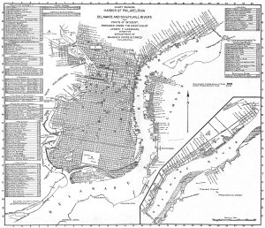
Map of Philadelphia Harbor, Delaware and Schuylkill, 1912
![2008 map showing historic Dock Creek with adjacent historical features](https://waterhistoryphl.org/wp-content/uploads/dockcreekAPSmap.jpg?w=300)
Map of Historic Dock Creek
![](https://waterhistoryphl.org/wp-content/uploads/1872-20040570081-East-Park-reservoir.jpg?w=300)
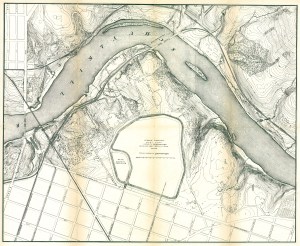
Fairmount Park topographical map, showing East Park Reservoir, 1872
![](https://waterhistoryphl.org/wp-content/uploads/DrippsComposite_edit.jpg?w=300)
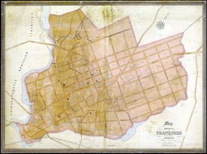
Dripps map of Frankford and vicinity, 1849
![Pennypack Park and Creek map, Roland Williams, 2005](https://waterhistoryphl.org/wp-content/uploads/2005_PennypackPark_RolandWilliams.jpg?w=300)
Pennypack Park Map
![](https://waterhistoryphl.org/wp-content/uploads/Noll1897_fullsize_edit-pdf.jpg)
Noll’s New Official Guide Map of Philadelphia, 1897
![Plan of Philadelphia, John Hills, May 30, 1796](https://waterhistoryphl.org/wp-content/uploads/graff02.04_Hills-map-1794.jpg?w=300)
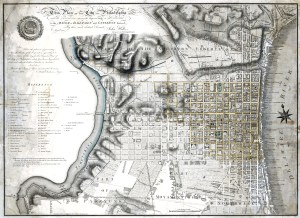
Plan of Philadelphia, John Hills, 1796
![Frankford borough map, 1845](https://waterhistoryphl.org/wp-content/uploads/Frankford-borough-1845-Shallcross-HSF.jpg?w=300)
Map of Frankford Borough, 1845
![](https://waterhistoryphl.org/wp-content/uploads/Delaware-City-Archives-NavyYard.jpg?w=300)
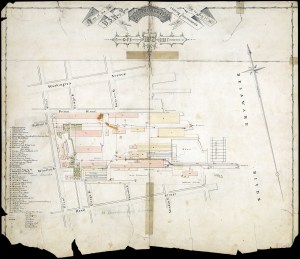
Philadelphia Navy Yard, July 1872
![Hopkins Darby 1877 map](https://waterhistoryphl.org/wp-content/uploads/Hopkins1877_Darby_AEL-scaled.jpg?w=300)
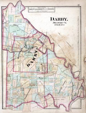
Darby, Delaware County, Pennsylvania, 1877
![Birkinbine Schuylkill Hydrographical Survey 1861-66](https://waterhistoryphl.org/wp-content/uploads/2008.001.0053_Hydrographical-Schuylkill-1866-2-reduced.jpg?w=300)