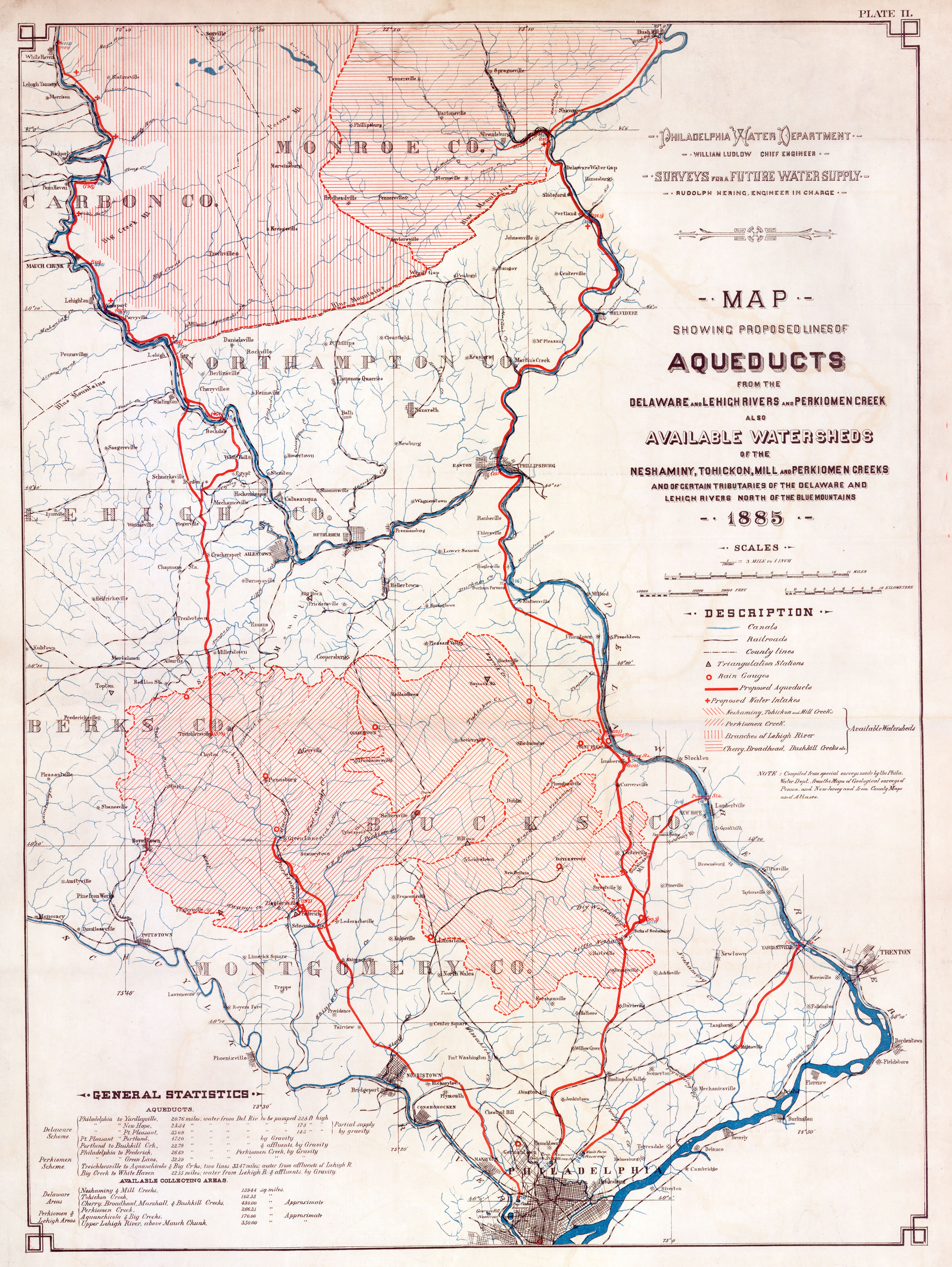
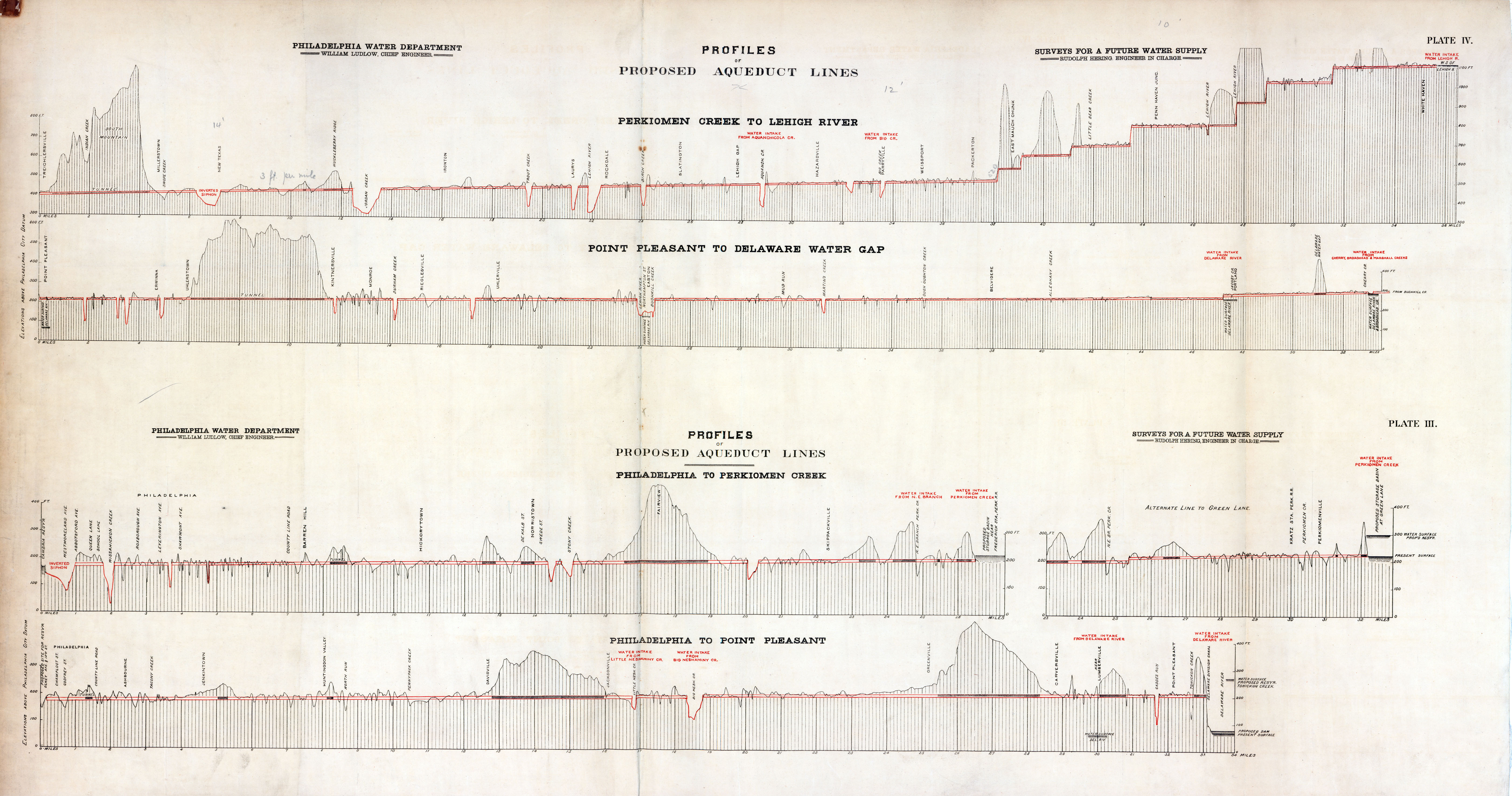
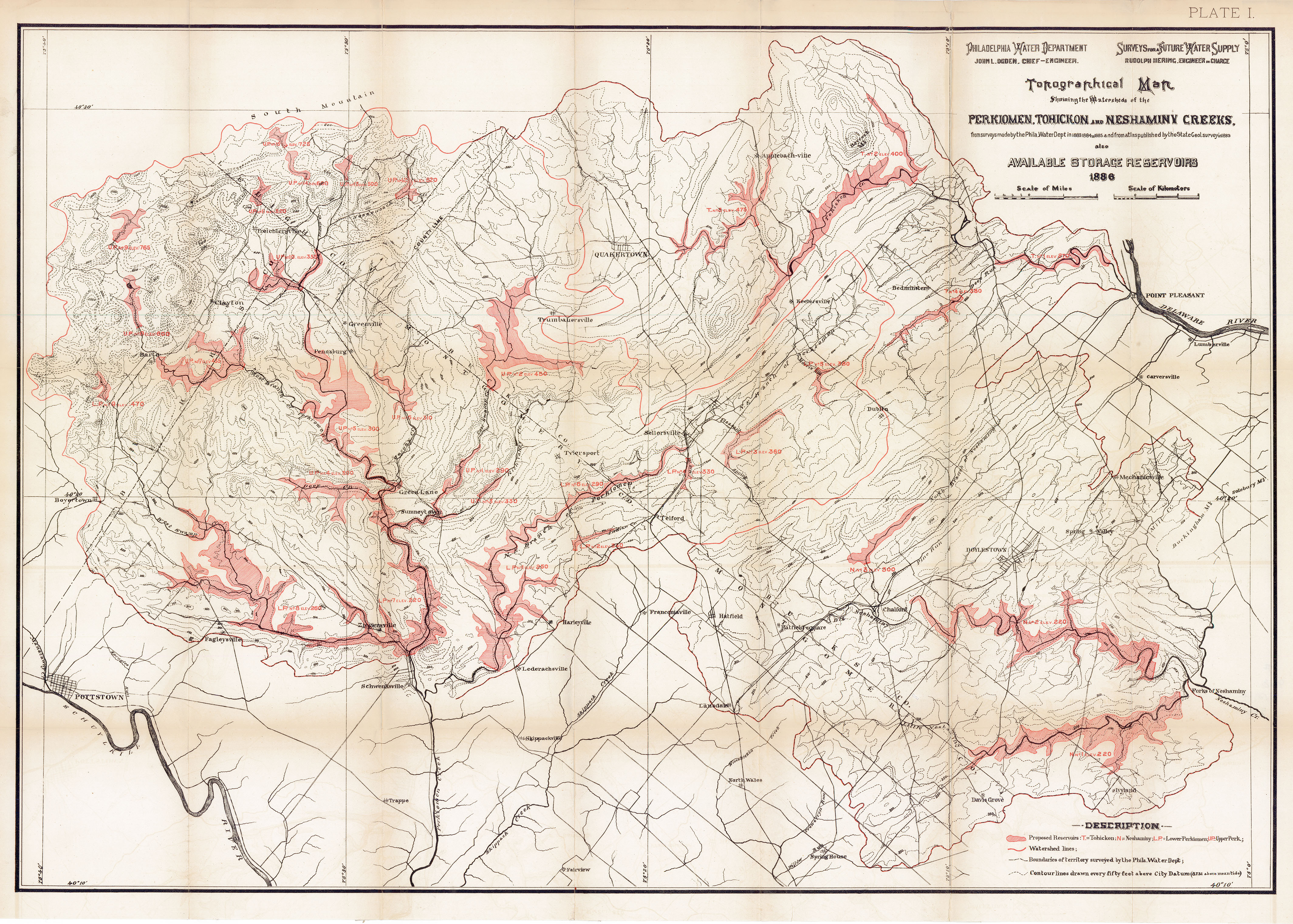
Surveys for a future water supply for Philadelphia, 1883 to 1886
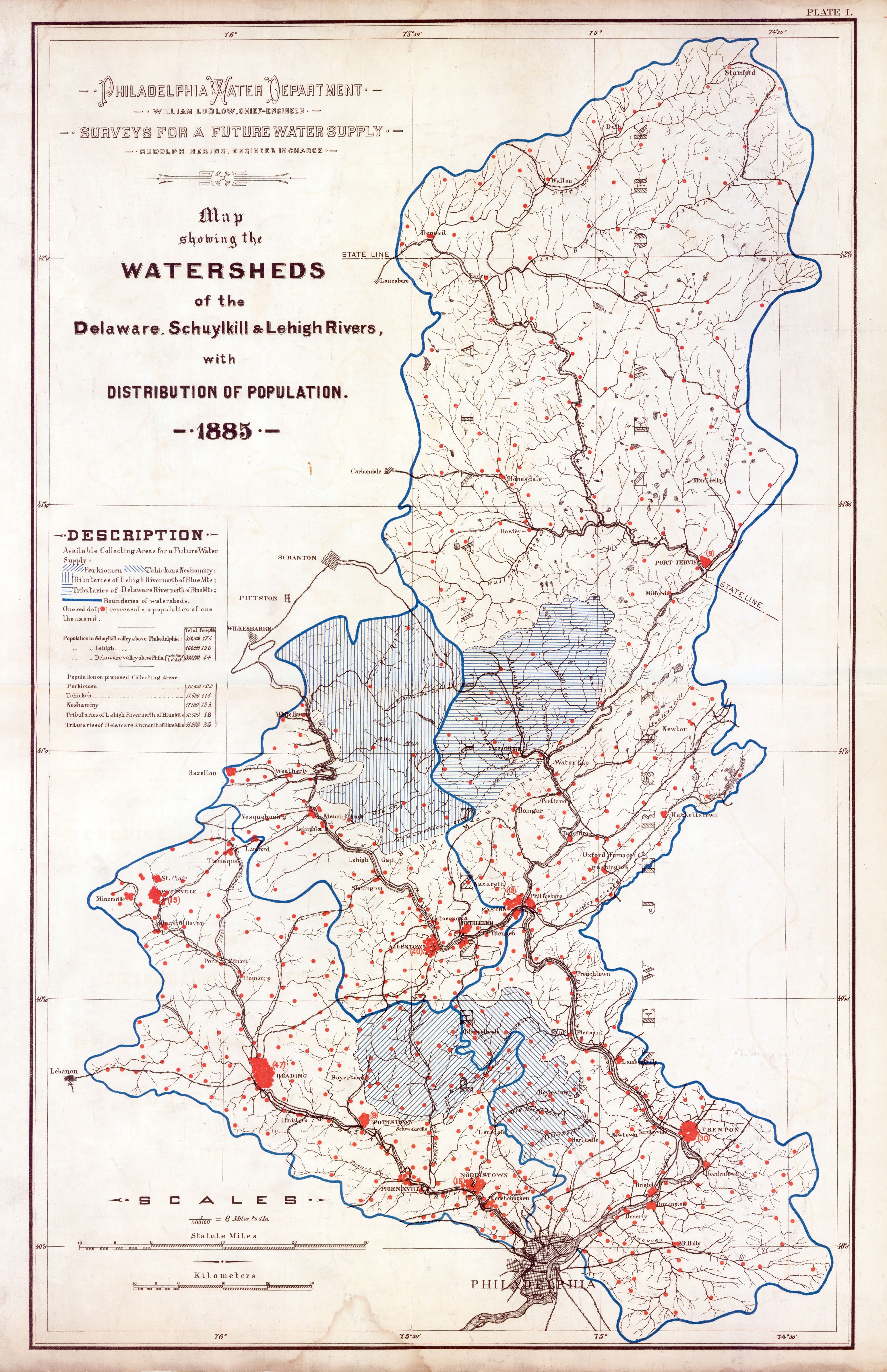
These beautiful maps were part of a four-year effort to find a cleaner (and safer) water supply for Philadelphia to replace the Schuylkill and Delaware rivers, which were becoming increasingly polluted by sewage and factory wastes. This effort focused on damming streams in upstate watersheds and carrying the water into the city via aqueducts. This work was led by Rudolph Hering (1847-1923), who had been an assistant engineer for the city’s Department of Surveys until the early 1880s. Hering was sent to Europe in 1880 to look at sewerage works in several countries, and when he came home he wrote a report that included a less-than-positive assessment of the Philadelphia system. This report got him into hot water with his boss, Chief Surveyor and Engineer Samuel L. Smedley. Hering left the Department in 1881, only to be hired back a few years later as “engineer in charge” of the “surveys for a future water supply.”

The 1880s plan – like all the plans for a new water supply that were ever made for the city – was never undertaken. Philadelphia, with three water filtration plants, still gets its drinking water from the two rivers that run through it.
For more information than you would ever want to know about the Hering’s plan, you can consult the PWD annual reports for 1883, 1884, 1885, and 1886. The reports include surveys of all the major watersheds north of Philadelphia; accurate rainfall and stream flow records; and many proposals for reservoirs. If you don’t have the time to read all these reports, with maps on this page serve as a visual summary of this work.
NOTE ON THE SCANS
I made these scans about 15 years ago, and because of the limits of technology at the time, they were only scanned at 150 dpi. That said, the details should still be easily readable. The annual report volumes had paper copies of all these maps folded in; the maps with the yellow fold lines were among those. PWD also had unfolded linen-backed copies of two of the two maps, from which I made the cleaner, unlined scans presented here.
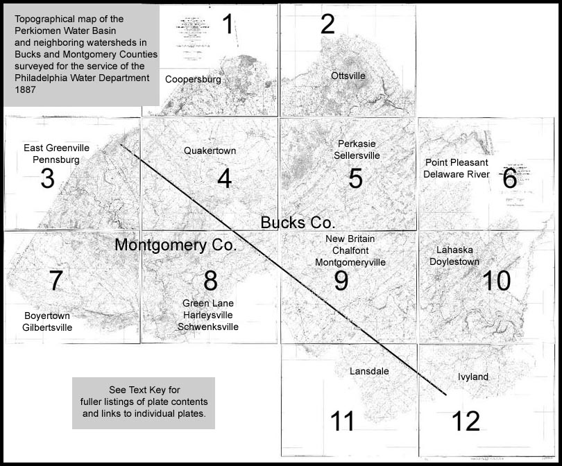
Counties surveyed for the service of the Philadelphia Water Department by William Ludlow, Chief Engineer, Rudolph Hering, Engineer in Charge, F. L. Paddock, Chief Topographer. Published by the Geological Survey of Pennsylvania to assist and illustrate the exploration of the Triassic belt. On a horizontal scale of 1600 feet to one inch with lines of vertical elevations every 10 feet. J. P. Lesley, State Geologist, Charles Ashburner, Geologist in Charge. 1887
The image above serves as an index to 12 topographical maps, created for the Pennsylvania Geological Survey, that are part of the PWD collection. These cover parts of Montgomery and Bucks Counties, north of Philadelphia, and were used as the basis for the smaller Perkiomen, Tohickon, and Neshaminy map above it.
I spent a long time piecing together a composite of my old scans of these 12 maps, which is too large to present on this site in any form. After doing this, I checked online and found a set of scans twice the resolution of the ones I made years ago. These can be seen at a comprehensive Penn State Libraries digital portal that includes scans of all the reports and maps created by the four Pennsylvania Geological Surveys.
The twelve contiguous sheets show proposed aqueducts, conduits, dam sites, and watershed boundaries, as well as roads, houses, barns, creameries, tanneries, shops, machine shops, shoe shops, hay houses, post offices, ice houses, seminaries, factories, mills (including many grist and saw mills), mill races, hotels, schools, churches, tollhouses, stores, railroad stations, and other structures, cemeteries, woodland, rain gauges, stream gauges, and triangulation stations. Some of the specific places, creeks and railroads named on these maps are listed below.
- Sheet 1: North Pennsylvania Railroad, Coopersburg Station, Steinsburg, California, Richlandtown
- Sheet 2: Stony Point, Stony Garden, Haycock Creek, Haycock Run, Haycock Mountain, Bucksville, Kimball’s Creek, Applebachsville, Tohickon Creek, Ottsville
- Sheet 3: Macoby Creek, Krausdale, Perkiomen Creek, Hossensack Creek, Perkiomen Railroad, Palm Station, East Greenville, Pennsburg, Perkiomen Creek (Northwest branch), Niantic Post Office, Hillegass Post Office
- Sheet 4: Licking Creek, East Swamp Creek, Quakertown, Tohickon Creek, North Pennsylvania Railroad, Milford Square, Spinnerstown, Scheetz’s Church, Molasses Creek, Beaver Run, Morgan Run, Bunker Hill, Ridge Hill Post Office, Trumbauersville, Hazelbach Creek, Geryville, Kleinville, St. Paul Lutheran Church, Millville, Butter Creek, Smoketown, Rich Valley Creek, Rich Valley Church, Marlboroughville, Hoppenville, Red Hill Post Office, Perkiomen Railroad, McLean’s Station, Macoby Creek, Naceville, Schlichterville
- Sheet 5: Keller’s Church, Mink Run, Tohickon Creek, Deer Run, Wolf Run, Rocky Ridge, Keelersville, Bedminsterville, North East Branch of Perkiomen Creek, Hagersville, Rock Hill Station, North Pennsylvania Railroad, Morris Run, Dublin, Blooming Glen, Perkasie, Sellersville, Bridgetown
- Sheet 6: Delaware River, Tohickon Creek, Wormansville, Byram Station, Point Pleasant, Smith’s Corner, Pipersville, Hinkletown, Plumsteadville, Gardenville, North Branch of Neshaminy Creek, Danborough, Ingham Spring
- Sheet 7: Cedarville, Sassamanville, Pleasant Run, Deep Creek, Schlegel Run, West Swamp Creek, Middle Creek, Gilbertsville, Boyertown, Engelville, Christman’s Mill, New Hanover Square, Frederick, Goschenhoppen Run, Proposed new location of Perkiomen Railroad, Keller’s Church, Ministers Creek, New Hanover, Fagleyville
- Sheet 8: Green Lane, East Swamp Creek, Tylersport, East Branch of Perkiomen Creek, North Pennsylvania Railroad, Telford, Indian Creek, Rich Valley Creek, Sumneytown, Perkiomenville, Kratz Station, Perkiomen Railroad, Hendricks Station, Mechanicsville, Tabor Church, Goschenhoppen Church, Branchville, Franconia Square, Salfordville, Salford Station, Zieglersville, Frederick Station, North East Branch of Perkiomen Creek, Harleysville, Lederachsville, Schwenksville
- Sheet 9: North Pennsylvania Railroad, Portland, Pleasant Spring, Fountainville, New Galena, North Branch of Neshaminy Creek, Mount Pleasant, Leidytown, Hilltown (Triangulation Station), Snoveltown, Mill Creek, Pine Run, New Britain, Chalfont, Line Lexington, Upper and Lower Hatfield, Hatfield Square, West Branch of Neshaminy Creek, Colmar, Doylestown Branch of North Pennsylvania Railroad, Tradesville, Roberts Farm, Montgomeryville
- Sheet 10: Landisville, Mechanicsville, Greenville, Lahaska, Buckingham Mountain, Centreville, Spring Valley, Doylestown, Doylestown branch of North Pennsylvania Railroad, Watsons Creek, Solebury Mountain, Pidcock Creek, Forestville, Bushington, Bucks County Alms House, Bridge Point, Bridge Valley, Concord, Robin Run, Mill Creek, Big Neshaminy Creek, Little Neshaminy Creek, Forks of neshaminy, Rush Valley Post Office, Jamisons Corners, Newville
- Sheet 11: Lansdale, Montgomery Square, Little Neshaminy Creek, Horsham (Triangulation Station), Horsham Road, Prospectville, Three Tuns
- Sheet 12: Warrington Square, Little Neshaminy Creek, Jacksonville, Hartsville, Davis Grove, Carroll’s House (Triangulation Station), Ivyland, North East Pennsylvania Railroad, Breadysville, Johnsville (Railroad Station)