
A few years ago, PWD engineer Sue Patterson spearheaded a project to scan all the existing sewer design files. Once the scanning was done, she selected about 15 boxes of these files for archiving in the PWD Historical Collection. Sue knows my interest in the city’s drainage history, and many of the files she saved describe the design process and justifications for sewers built to capture streams.
Earlier this year I began looking through these boxes, and I was excited to find a bulging file folder relating to a small stream in the city’s Oak Lane neighborhood. The stream had no official name—none that had ever appeared on any city maps, or in any database of USGS stream names—but because it empties into Tacony Creek near Adams Avenue, it has come to be known as Adams Run.
Even if Adams Run and I didn’t share the same first name, I would still find it interesting. It was one of the last living streams that the city buried in a sewer. Putting the stream underground allowed a multi-unit complex appropriately called the Adams Run Apartments to be built in its little valley.
In September of this year I visited the Adams Run valley with Lou Lescas, who grew up in Northeast Philadelphia and has a photographic memory for the city’s buildings and landscape. For years Lou helped the Philly History website, run by the Philadelphia City Archives, locate thousands of pictures for which they had no addresses. Lou made these identifications in a variety of ways (which he describes in this blog post at the Hidden City website), including the use of the PWD engineering records, which is how he and I met. Lou was familiar with Adams Run, and he drove me through the neighborhood, armed with copies of old maps and aerial photographs, as we searched for evidence of the stream’s former existence.
The headwaters of Adams Run, just east of the Oak Lane Reservoir, are now covered by the Sturgis Recreation Center and Playground. From there the stream flowed in back of the former Cardinal Dougherty High School, located at 64th Avenue and 2nd Street, which is now home to a private Christian academy. A valley is still evident between the school and the adjacent playing fields, and Lou and I were excited to see a fenced-in wet area below one of the school’s parking lots. I later learned that this not a remnant of the stream, as we had imagined, but a stormwater retention basin installed in 2013.
After leaving the school grounds, the sewer traverses a patch of woods before entering the Adams Run complex. We followed the meandering driveway, which mimics the twists and turns of the sewer that runs beneath, with stormwater entering through numerous inlets. The sewer then crosses Crescentville Avenue just north of Adams Avenue. Once in Tacony Creek Park, the stream is liberated from the pipe for a short stretch before flowing into Tacony Creek.

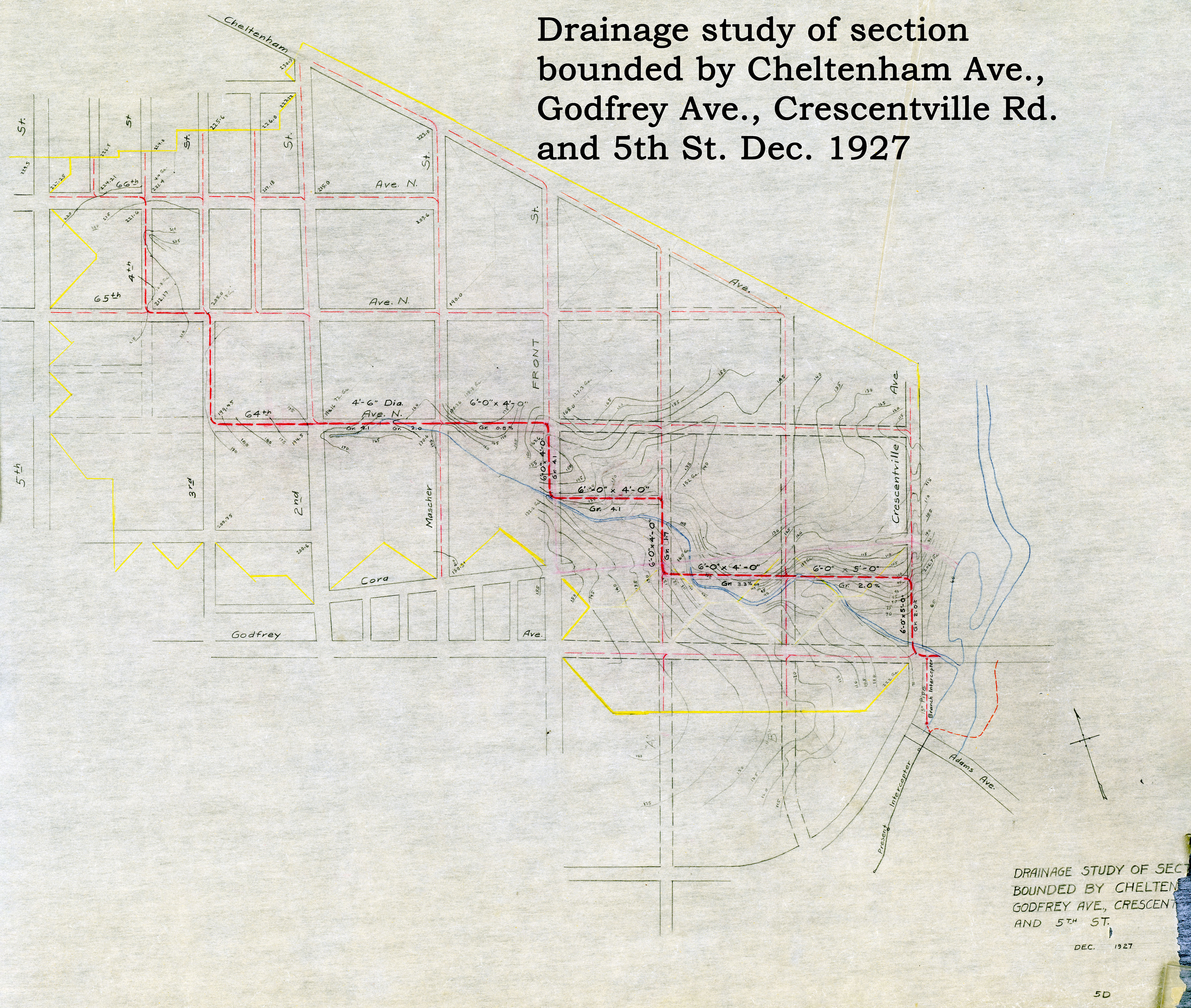
As I discovered in the sewer design project file, this particular stream to sewer conversion had been instigated in the late 1950s by Rev. George T. Concannon, principal of Cardinal Dougherty High School. In 1959, after discussions with various city officials, Concannon commissioned a private engineering firm to produce a report that would justify putting the stream in a pipe. He presented the plan to city engineers, and then lobbied Samuel S. Baxter, commissioner of the Water Department – which is in charge of sewer construction and maintenance – to get the job done. Baxter reluctantly agreed to undertake the project, ouilining his reasoning in a May 6, 1959 letter to John Briggs, one of his assistants:
“For the past year or so there have been discussions and correspondence among this department, Councilman Finley, and Councilman Carr, and the principal of the Cardinal Dougherty High School. They have urged that we enclose in a conduit a stream which flows east from 2nd Street, north of the high school building….I have visited the site several times and walked over it. It has all the possibilities of being a nice open area with a small water course, with cover for birds and small animals. Unfortunately, it seems impossible to keep some people from actually littering the area, and it has become somewhat of a nuisance to the school and the neighborhood. I hate to see a stream valley of this type lost, but I have reluctantly agreed with Councilman Carr and the principal of the high school that we would enclose the section between 2nd Street and Front Street, including the Mascher Street branch.”
Seven years passed before money was allocated for this work, but in 1966 the stream was finally enclosed in a stormwater sewer.

I later found the plan below (not included in the Adams Run sewer design folder) that indicated that the stream may have been considered for burial as early as 1927.
As far as I have been able to determine, the burying of Adams Run was the last creek-to-sewer project in the city, and before learning about it I had thought that the city was long-finished with this type of work. In the first quarter of the 20th century, the valleys of Indian Creek in West Philadelphia, Carpenters Run in Mt. Airy, and Wooden Bridge Run in Northeast Philadelphia – all originally slated to be buried in sewers – had been saved and made extensions of adjacent parks. Adams Run, if preserved, could easily have become a similar extension of Tacony Creek Park.
In those days, engineers like Baxter were most comfortable dealing with hardscape and structures – roadways, bridges, sewers – and were less familiar with how to treat the natural world in a way that preserved both the lay of the land and accommodated human needs. In 1959 the city was still expanding on its outer edges, and so this stream was obliterated to make way for more houses, as so many had been before it.
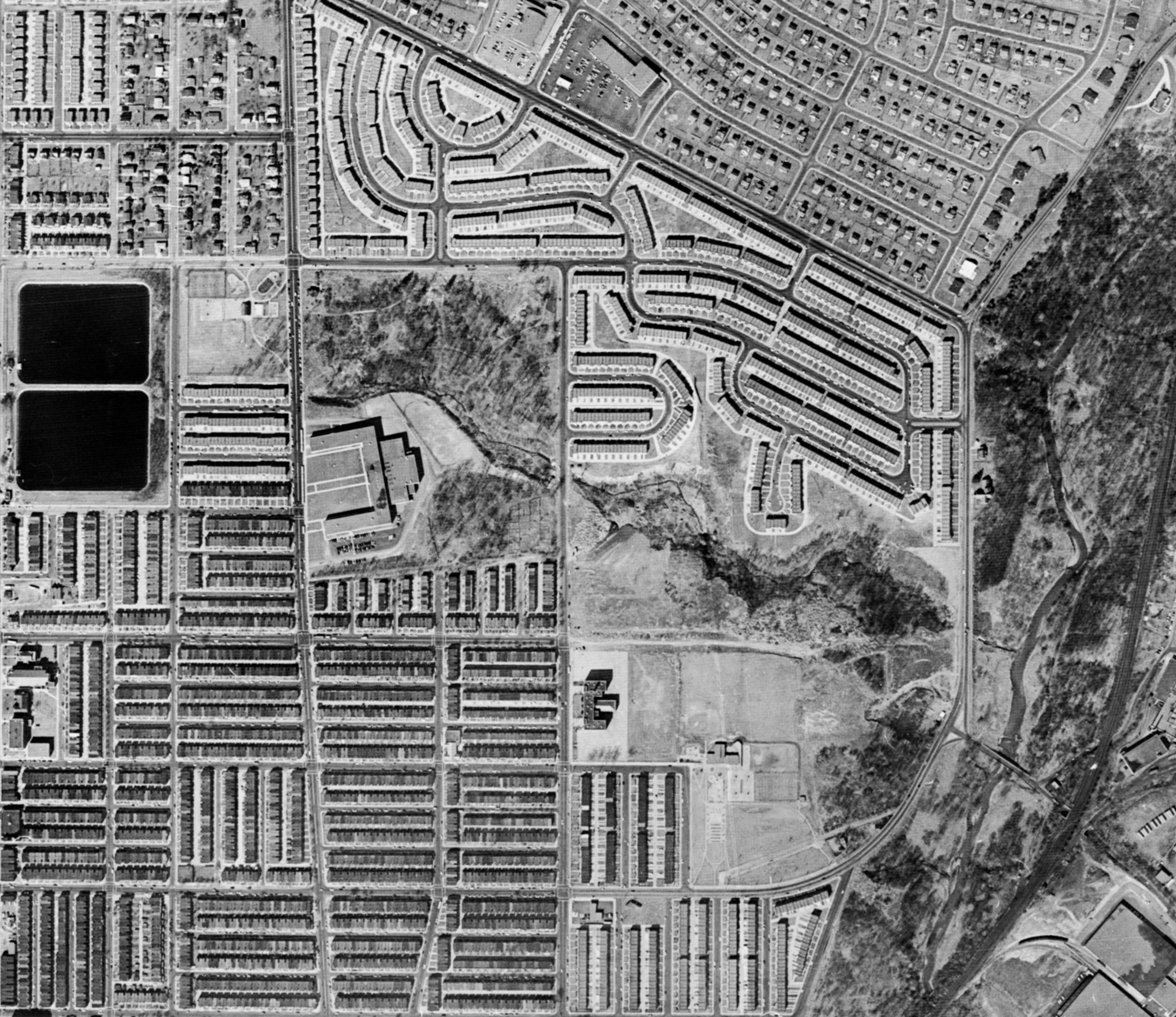

Bottom: 1970 view after the stream was put into a sewer.
(Delaware Valley Regional Planning Commission)