Three maps from the
1870 Annual Report of the Commissioners of Fairmount Park
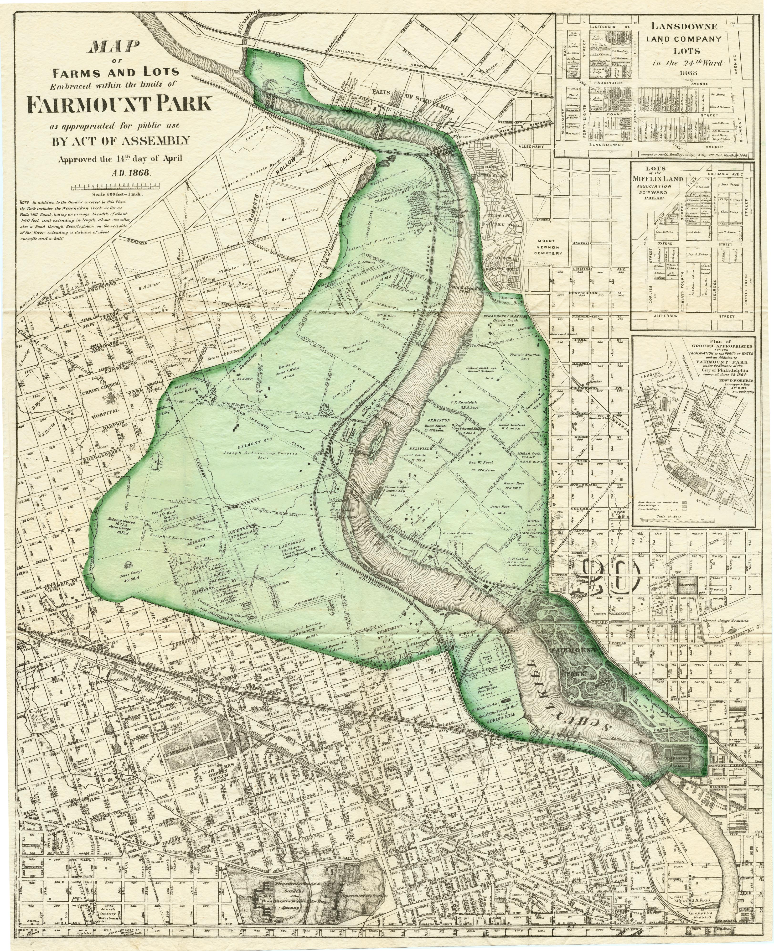
In 1868, Fairmount Park was enlarged to more than 2000 acres with the purchase of land on both banks of the Schuylkill River. One goal of this purchase, and a later purchase of land along Wissahickon Creek, was to protect water quality in the river, which by then was used as source water for four drinking water pumping stations in Philadelphia. The following three maps document those early years of the enlarged park. All three were bound into the Second Annual Report of the Commissioners of Fairmount Park, published in 1870. While they are available in many other places, I thought it might be useful to post all three maps in one place. As with many of my favorite maps, these are both informative and beautiful.
TITLE BLOCK Map of farms and lots embraced within the limits of Fairmount Park as appropriated for public use by Act of Assembly approved the 14th day of April AD 1868. Inset maps: 1. Lansdowne Land Company lots in the 24th Ward, surveyed by Saml. L. Smedley, Surveyor & Regulator, 11th Dist., March 24, 1868. 2. Lots of the Mifflin Land Association, 20th Ward Philada. 3. Plan of ground appropriated for the preservation of the purity of water and an addition to Fairmount Park under ordinance of the City of Philadelphia approved June 28, 1864. Edwd. D. Roberts, Surveyor and Reg. 4th Dist. Nov. 26th 1864.
DATE 1869 ca.
OTHER VERSIONS You can view this same copy of the map at full resolution at the Greater Philadelphia Geohistory Network. The Graff Collection at the Franklin Institute, which is co-administered by the Philadelphia Water Department, includes this plainer version, without the green coloring.
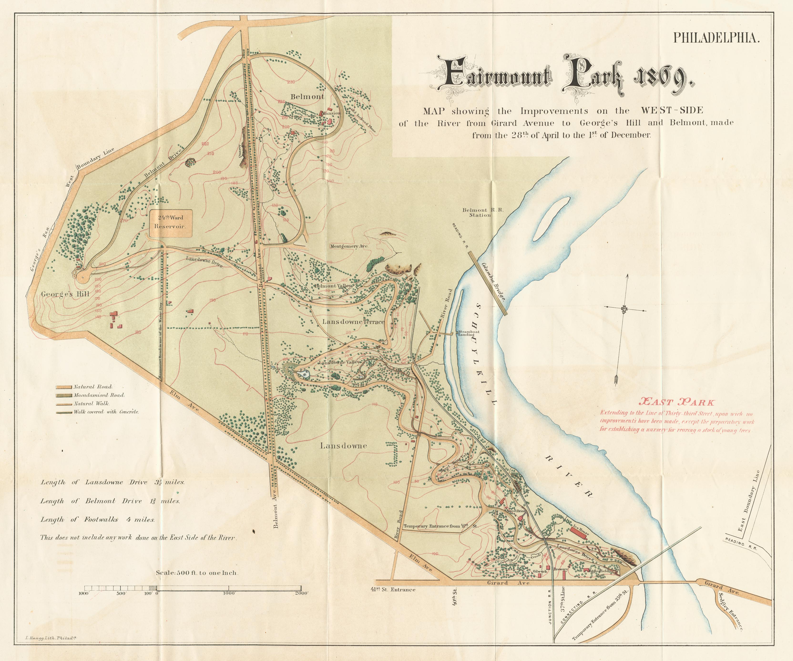
TITLE BLOCK Fairmount Park 1869. Map showing the improvements on the west-side of the river from Girard Avenue to George’s Hill and Belmont, made from the 28th of April to the 1st of December. L. Haugg, Lith., Philada.
DATE 1869 ca.
BETTER VERSION You can view this same copy of the map at full resolution at the Greater Philadelphia Geohistory Network.
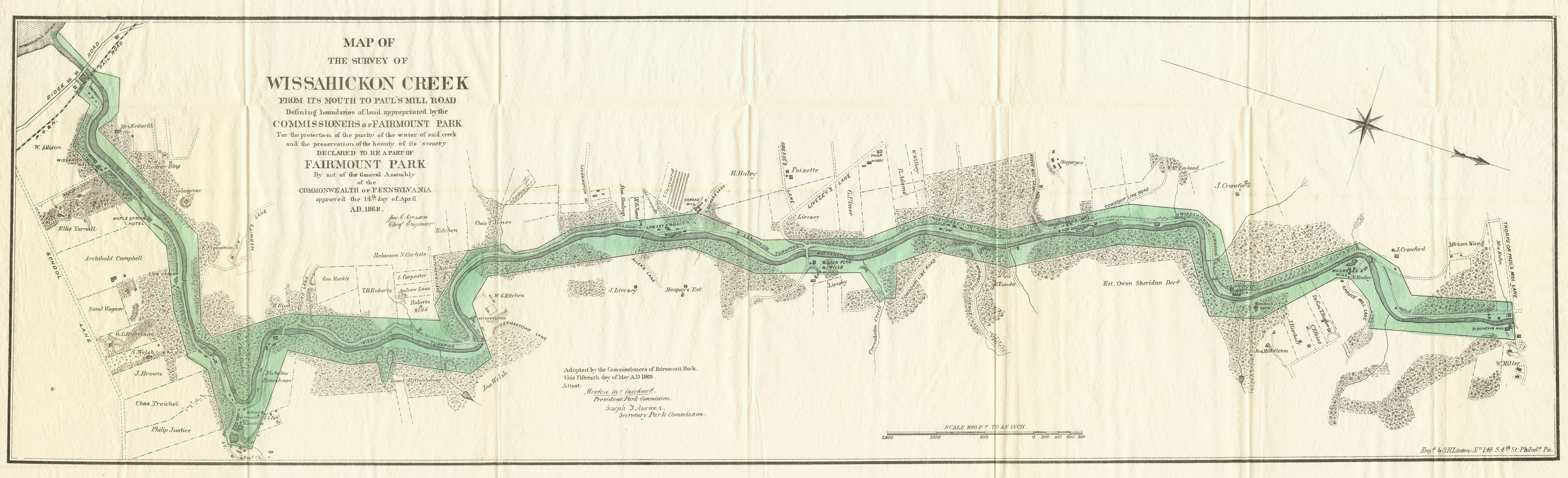
TITLE BLOCK Map of the survey of Wissahickon Creek from its mouth to Paul’s Mill Road defining the boundaries of land appropriated by the Commissioners of Fairmount Park for the protection of the purity of the water of said creek and the preservation of the beauty of its scenery. Declared to be a part of Fairmount Park by Act of General Assembly of the Commonwealth of Pennsylvania approved the 14th day of April A.D. 1868. Adopted by the Commissioners of Fairmount Park this fifteenth day of May A.D. 1869. Attest: [Signed] Morton M. McMichael, President Park Commission; [signed] Joseph F. Mercer, Secretary Park Commission.
DATE 1869 ca.
BETTER VERSION You can view this same copy of the map at full resolution at the Greater Philadelphia Geohistory Network.
AMAZING VERSION While searching through the City Plans collection of the Streets Department about 10 years ago, I found the original hand-drawn plan from which the lithographed map was made. It is about three times as large as the lithograph, measuring 28 x 96 inches. You can view this map at (you guessed it) the Greater Philadelphia Geohistory Network. The original is now housed at the Fairmount Park Historic Resource Archives.