The Public Ledger, one of Philadelphia’s many daily newspapers in the 19th century, also published an almanac that was distributed for free to its subscribers. The almanacs, published annually from the late 1860s to about 1900, crammed loads of useful information, printed in tiny type, into their 60 small pages. This included astronomical data – the times of sunrise and sunset, moonrise and moonset, high tide and low tide for every day of the year. Page after pages listed municipal, state, and federal officials. The 1879 edition included a list 14 pages long for all the religious institution in the city along with the names of their pastor and the times of their services. (Does anyone out there know anything about the intriguingly named Christadelphians, and what they believed?) Other regular features included a chronology of the past year’s notable events, along with a necrology, or list of the eminent people who had died.
One-off articles, often on historical topics, also appeared in these almanacs. Three of these were related to the city’s rivers and streams. An 1879 article listed the names of streams in the city as found on old maps, just as some of those streams were being put into underground sewers as city neighborhoods expanded across their valleys. The 1882 almanac included two articles—“Islands in the Delaware and Schuylkill Rivers within the boundaries of Philadelphia,” and “Ancient ferries in Philadelphia”—that describe other features of the landscape, some of them still around today, and others that were gone even then.
Because of its relevance to WaterHistoryPHL (and because I wanted all these names to turn up in keyword searches) a transcript of the streams article appears below. If you’d rather download a PDF that includes all three articles, to read at your leisure, click the almanac cover below.

Changes in the names of streams in and about Philadelphia
(Source: Public Ledger 1879 Almanac: Philadelphia: Collins, Printer [1878], odd-numbered pages 3-13)
THE FOLLOW IS BELIEVED to include all the streams of any magnitude within the boundaries of Philadelphia as the same were noticed from the discoveries by the Dutch and Swedes up to the present period. Many of these streams are obliterated. For convenience’ sake the descriptions are made with reference to localities which now exist. The sources from which information is obtained are to be found in patents, deeds and old maps, the dates of the latter of which are as follows:
Roggeveen’s, 1678; Peter Lindstrom’s, a Swedish engineer’s map of the Delaware River, 1654-1655. The original map was taken to Sweden. A copy was procured many years ago by the American Philosophical Society. It is peculiar in this, that many of the names are in the Indian, Swedish and French languages. A copy of this map, differing in several matters, particularly in some of the names, and omitting the French names altogether, is to be found in Nya Swerije, by Thomas Campanius Holm, published at Stockholm in 1702. Another copy of Lindstrom’s map is in the History of New Sweden, by Israel Acrelius, 1759, and this also has some changes in regard to names.
Other maps referred to are those of Thomas Holmes (Penn’s first surveyor), 1685; Scull & Heap, 1750; Reed, 1786; John Hill, 1796; Varlo, about 1798; Nicholas Hill, 1808; Mellish, 1816; Ellett, 1839; and some others not necessary to be named.
Asoepecka sea. On Lindstrom’s map, in the Delaware River, in front of the present city, between a point which might have commenced about the mouth of Gunner’s Run and extended to Frankford creek, a shoal or bank is marked with dots, to which is assigned the following names: Foglesand, Mer Asoepecka, Sable des Oisseaux ou Alsoepecka. Foglesand in Swedish means “bird-bank.” Sable des Oisseaux may be interpreted “blackbirds,” so that the bank would be “blackbird bank.” The Delaware in front of this bank is wide; hence it may be supposed the title Mer Alsoepecka (“Alsoepecka sea”) was applied to that portion of the river opposite the bank. M.S. Henry thinks that Alsoepeck should be Assiscupeck (“a muddy stream”). It may be mentioned that Ashopock is the Indian word for “hemp.”
Beaver Creek, flowing through the Almshouse grounds, and emptying into the Schuylkill opposite Pine Street. Called Beaver Creek and Beaver Run in a patent by Penn to Varels Landers in 1692.
Boon creek or Church creek runs west by south from the junction of Kingsess and Minquas creek. It received its name from Andreas Boon, one of the original Swedish settlers. It was also one of the routes to the church at Tinicum; hence its name of Church creek.

Botanic creek flows into the Schuylkill on the west side, opposite the upper part of Point Breeze and below Eastwick’s, formerly Bartram’s Botanic Garden, from the proximity to which it obtained its name.
Bow creek, southern boundary of Philadelphia City, flows from Darby creek, along the northeastern side of Tinicum Island, and, after a short bend nearly due east, enters the Delaware opposite Hog Island. It is called on Lindstrom’s map “Booke, Eller Kyke Kylen,” “La Riviere de Hetres ou d’Eglise.” “Boke” is Swedish for beech tree, and “Hetre” is French for the same; “Eglise” is French for church, and “Kyke” is evidently an abbreviation or misspelling of the Swedish “Kyrke”–church; so that the stream was sometimes called Beech creek and Church creek. It obtained the latter name from the fact that it was a route traveled by water to the Swedish church at Tinicum. Campanius calls this creek “Boke,” from which the corruption to Bow is easily traceable.
Brier creek empties into the Schuylkill on the west side in Fairmount Park below Sweet Brier Mansion. It is so called on the map of H.P.M. Birkenbine.
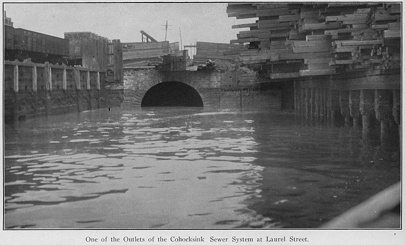
Cohocksink creek [obliterated] is called in various patents Cococksink, Coxing, Cogogsink, Coxon and Cohocksink or Mill creek. M.S. Henry, in his Dictionary and Gazetteer of Words and Names in the Delaware Indian Language, defines the name to be Cuwehockin–“pine lands.” The name Mill creek was given to it from the fact that on this stream, between the present Fifth and Sixth Streets, was built the Governor’s (Penn’s) Mill, and afterward the Globe Mills. One branch of the Cohocksink commenced near the Ford Road, west of the Lamb tavern, and there was a branch, which rose above the present Glenwood Cemetery. The stream flowed generally southeast, crossing Broad Street above Turner’s Lane, and crossed the latter about the line of Twelfth Street. It continued to a point between Fifth and Sixth Streets, where it widened into a lake, into which also flowed a stream, which rose in the lands of the Gratz estate, probably above Jefferson Street and flowed eastwardly. The latter was called Coozaliquenaque in the patent to Daniel Pegg in 1684. From the pond or mill-dam, flowing east and south, the Cohocksink emptied into the Delaware at Brown Street.
Dam creek [obliterated] ran into Hollander’s creek in a direction south by west, and had its source near the Buck Road. It is so called on Scull & Heap’s map.
Darby Creek [sic: Cobb’s creek} empties into the Delaware River opposite the lower end of Tinicum Island. It is the lower portion of a stream, which rises in Haverford Township, Delaware County, and flows with some irregularities and curves in a southerly direction until it reaches the Blue Bell Tavern, on the Darby road. The upper portion of this stream was called by the Swedes Kara Kung or Kakaron, Carkoens, Carkons, Carcoens, Carcoon and Chargoes–all supposed to be corruptions of Kara Kung. Mr. Henry thinks that this name is derived from a mortar or mill in which the Indians pounded their corn, and that it was given to it after Governor Printz built a mill upon this stream, which was probably about 1643. On Holmes’ map this creek is called Mill creek. The name was shortly afterward changed to Cobb’s creek, after William Cobb, an Englishman, who became owner of the old mill. [Tributaries to Darby Creen include:
— Port Reading creek rises near Haverford College, in Delaware County, flows through Haverford township and empties into Cobb’s creek between Haverford Road and Church Road.
— Indian Run is composed of two branches, one of which rises in Lower Merion, near Ardmore station, and the other north of Elm station, on the Pennsylvania Railroad. They flow south, and unite a short distance before reaching Cobb’s creek, into which they flow.
— Blanson’s run rises in Darby township, and empties into Cobb’s creek near Paschallville.–Naylor’s run rises in Marple township, and flows south and east into Cobb’s creek.
—Hermsprota creek empties into Darby creek near the intersection of Amesland Road and a road leading to Hog Island, a short distance above Bow creek.
— Pusey’s run empties into Darby creek above the junction with Cobb’s creek, near the borough of Darby.
—Amesaka run (patent to Neals John, 1684), Ameasaka (patent to Mounce Jones, 1685) rises in Philadelphia, and runs into Cobb’s creek near Mount Moriah Cemetery [Also known as Thomas Run].
–Below the Blue Bell Tavern a creek joins with Cobb’s creek, which was called the Nyecks meaning (“nasty” “muddy”), the Muckruton, and Amesland (after Amas-land, “the land of the nurse”), which was given by the Swedes to the country immediately south of it. Below this junction the creek was called Darby creek, from the town or village of Darby, near by. It was also called Church creek, because at one time it was a convenient road of travel to Tinicum church.
—Muckinapattus creek rises in Darby township, Delaware County, flows south-west, and joins Darby creek, west of the junction with Bow creek. Muckinapalis means “land that is lower than the surrounding country.”
—Stone creek rises in Springfield Township, Delaware County, and flowing nearly south enters Darby creek not far from its mouth.

Dark Woods Run [obliterated] had its source in a spring which rose north of Girard College, and flowed through the western portion of the college grounds until it emptied in a large pond called Dark Woods pond, in the neighborhood of Brown Street, about Twenty-sixth or Twenty-seventh. The stream ran south-west, and emptied into the Schuylkill River not far from the Lincoln monument and a little west of the present steamboat-landing in Fairmount Park.
Delaware River was discovered by Henry Hudson, an Englishman in the service of the Dutch East India Company, in the yacht Halve-Maan or Half-Moon, of eighty tons’ burden, on the 28th of August 1609. Various Indian names have been assigned to this stream. Heylin, in his Microcosmos, or description of the world, published in 1622, calls the river Arasapha, which seems to have been derived from Arasaphe, “it goes fine,” meaning a river at all times navigable and useful. Poutaxat was another Indian name sometimes applied to the river, but supposed to be more applicable to the bay. It means round or broad, and is applied exclusively to bays. Makerish-kisken and Maris-kitton are corruptions of the name, which in early deeds is written Mochijirickhickon. Mochijirick means “large and great,” and hickon “ebb and tide;” so that this name meant “a large river in which there were ebbs and tides.” Another name was Lenape Whittuck. Lenape means “Indian,” and hittuck “a tree.” Kit-hanne, meaning “the largest river,” was also applied. After Hudson, the first explorer was Captain Cornelius Jacobsen Mey, who, in 1613, entered the river in the yacht Fortune, called the eastern cape Mey and the western Cornelis, another of the western capes being called Hindlop or Hinlopen, which latter name was subsequently transferred to Cape Cornelis. The original Cape Hinlopen, near the present town of Lewes, lost its designation as a cape altogether. Mey, on his return to Holland, left behind him a Captain Hendrickson in the yacht Onrust (Restless), who explored the river, it is believed, as far as the mouth of the Schuylkill. On his return to Holland, Hendrickson accompanied his report with a map, on which the river now called the Delaware was designated as the riviere Van der Vorst Mauritius. But Mey had already chosen as a name the Zuydt or South River, in contradistinction from the Nord or North River. The Dutch also called the stream Nassau River, Prince Hendrick’s river and Prince Charles’ river. When the Swedes came they called it Swenska riviere or Swedish River, and it was also called New Swedeland stream, or the river of New Sweden. The English gave it the name of De la War, which has been modernized into Delaware. This name was given because they supposed that Thomas, Lord de la War, who touched at the bay in his voyage to Virginia in 1610, was the discoverer of the river, and as early as 1612 Captain Thomas Argall of Virginia, speaks of it as the De la War river. The name was therefore given to the river before that which was assigned to it by the Dutch, but the claim that Lord de la War was the discoverer was untenable, inasmuch as Hudson had entered the river in 1609. The bay of the Delaware was called by the Dutch New Port bay, also Godyn’s bay, after Samuel Godyn, a Dutchman, who made a purchase of land in 1629 from the Indians, extending from Cape Cornelis or Hindlop (Henlopen) inland thirty-two miles and two miles in breadth.
Dock creek [obliterated] was so called by the early settlers because it was the place at which a public dock was situated. It was composed of two branches, one of which commenced between Fourth and Fifth Streets, north of Market, and ran south by east, crossing Market Street west of Fourth, and Chestnut Street about the line of the present Hudson Street, and by the latter south in rear of the property of the Board of Brokers, where it was joined by a branch which began west of Fifth Street, below Walnut, and flowed toward the north-east. It crossed Walnut Street between Fourth and Fifth, near the building of the Schuylkill Navigation Company, and crossed Fourth Street opposite Thomas’ auction store. These streams, thus united, flowed eastwardly, bearing to the south, and formed the body of Dock creek, the course of which may be traced by the street of that name. Not far from the Delaware, this stream received the water of another branch, which began at about the site of St. Peter’s Church, at Third and Pine Streets, and crossed the square bounded by Second, Third, Spruce and Pine Streets until it struck the head of the present Little Dock Street, along which it flowed to the north-east until it reached the main stream. This branch was called Little Dock Creek. The Indian name of Dock creek was Cooconocon.
Eagle creek. From the junction of the Kingsess and Mingo creeks, a stream runs east for a short distance, and empties into the Schuylkill below the first bend in the river. This might seem to be a continuation of Kingsessing creek, and it has been so called on some of the maps. On Lindstrom’s map, it is called Ornebo Kyl, La Riveiere de Nid des Aigles (“the river of the eagle’s nest,” or “eagle’s nest river”). From this title was obtained the modern name, Eagle creek.
Falls creek [also called Dobson’s Run] enters the Schuylkill near the Falls, below the mouth of the Wissahickon, and near the Falls tavern.
Frankford creek is formed by the union of three streams. One of these, now known as the Wingohocking, is so called in a patent to Griffith Jones, 1684. It is called Winconico in a patent to John Goodson, 1701, and Wincokoe in a patent to Griffith Jones of the same year. Wingohocking is defined by Heckewelder to be “a choice spot of land for cultivation, a favorite place for planting, fine land;” whilst Mr. Henry says it means “lands in a hollow or valley.” In modern times, the Wingohocking has been called Logan’s run, from the fact that it flowed through the grounds of the seat of James Logan at Stenton. The Wingohocking rises near Mount Airy, curves generally to the south, and passing through Germantown runs eastwardly until it unites with Tacony creek near Rowland’s saw-mill. The Tacony rises in Montgomery County near Shoemakertown, runs south-west and south, crosses the line of the former Bristol township, and formed the boundary of Bristol and Oxford townships.
—Rock run enters into the Tacony south-west of what was formerly Whitaker’s factory.
–The Little Tacony rises near the Township-line Road between Dublin and Oxford, runs nearly south through Oxford township, and is joined by one or two brooks, and empties into the Frankford creek east of Frankford. The stream is now called Frankford creek from the junction of the Tacony and Wingohocking, and enters the Delaware near the U.S. Arsenal. Tacony is called Taoconik in a patent to Robert Adams, 1684; Toaconinck in a patent to Griffith Jones in the same year. Little Tacony is also called Tackawanna. Mr. Henry says Tacony is derived from Tekene and means “woods” or “an uninhabited place.” Into Frankford creek near the Delaware empties a stream called Freaheatah. Frankford creek derives its name from the village of Frankford, adjoining. On Lindstrom’s map it is called Aleskins Kylen, La Riviere des Anguilles Ecorchees (meaning “the river of skinned eels”), the origin of which can only be conjectured. A portion of the creek east of the junction of the Little Tacony is called Questioninck in a patent to Eric Cock and others, and Quissinuaminck in a patent to Thomas Fairman, 1688.
Green Tree run rises in the upper part of the late Roxborough township and runs nearly parallel with Green Tree Lane, and empties into the Schuylkill near the intersection of that lane and the Ridge Road.
Gunner’s run. One branch, called Three-mile Run, rose near Woodpecker Lane and Broad Street, and flowed east by south, crossing above Fairhill meeting near Germantown Road, having a branch through Harrowgate Garden, and a branch with two forks, one of which runs above the other below the Norris estate. Pursuing its way south-westwardly until near the Delaware, it makes a sudden bend south-east, and enters the river between the Dyottville glassworks and the Kensington water-works. This stream was called Tumanaramaming in a patent to Thomas Fairman in 1702, Tumananarmings on Reed’s map, and Gunner’s run by Scull & Heap. It received its name from Gunner Rambo, a Swede, who lived near it.
Hay creek, the eastern part of Hollander’s creek, extended from Holt or Hell creek into the Delaware at some distance north of Greenwich Point.
Hollander’s creek, according to the map of Lindstrom, made a clear course through from the Delaware to the Schuylkill, making the lower part of the Neck an island, which was further divided by other streams, so that there were three islands at the lower end of what is now considered fast land in Philadelphia, in addition to League Island. The westernmost was called Manasonk or Manayunk. It was adjoined on the east by Drufwe Island, Isle des Raisins or Grape Island, which was immediately north of League Island, and is now known as Greenwich Island. North of Drufwe Island was another, which has no name. Upon Lindstrom’s map Hollander’s creek is called Hollandare Kylen, La Riviere des Hollandois or Dutch River. But this is probably an error. It is more likely that the stream was named after Peter Hollandaer, a Swedish governor, who succeeded Peter Minuit as commandant at Fort Christina in 1639.
Holt creek flowed into Hollander’s creek west of Dam creek It was sometimes called Little Hollander’s creek, also Hell creek. It formed a curious loop in the upper portion, which encircled a piece of ground that might be called an island. The lower part of this loop was called Float creek.
Inckhorn’s creek runs into the Schuylkill River on the west side, near the bend, north of Penrose Ferry. The original name was Andreas Inckooren’s Kyl, from the residence of a Swede of that name near it.
Jonas’ creek was a stream with two branches nearly opposite each other in the shape of a cross. The branch from the east, in a patent in 1684, is called Jonas’ creek; Jones’ creek by Varlo. The main stream was called Spack creek in a patent to L. Cock in 1685 and Sneak’s creek on Heap’s map.
Kingsess or Kingsessing creek intersects Bow creek about halfway between Darby creek and the Delaware. It flows in a north-easterly direction, and empties into the Schuylkill nearly opposite Girard Point. This Indian word, according to Mr. Henry, is derived from Chingessing (“the place where there is a meadow”) or Chincessing (“bog meadow”).
Land creek empties into the Schuylkill on the west side, between Penrose Ferry and the bend of the river. It bears that name in a patent to Benjamin and Enoch Bonsall in 1705.
Little creek was north of Rogue creek, ran a short course, and emptied into the Schuylkill on the east side in 1750.
Malebore’s creek emptied into Hollander’s creek east of Ship brook, and no doubt received that name from Malebore, an Indian chief, whose name is signed to some of the early deeds to Penn. One branch of this creek rose near Fifteenth and Sansom Streets, and ran southwardly to a point south of Pine Street and east of Broad, where it was joined by a branch from Spruce Street between Seventeenth and Eighteenth. Farther down were branches from Eighteenth and South Streets, from Spruce and Twelfth Streets, and from Eleventh Street between Spruce and Pine. The united streams ran southward from Passyunk Road and Eleventh Street, inclining to the west, and bending in the shape of a hook into the marsh-land below Point Breeze until Hollander’s creek was reached. The upper part of this stream after the junction was called Shakhanoning in a patent to Stille and others, 1678; Sheckhaming in a patent, 1695; Shackhemensen (Scull & Heap); Chichansink (Mellish). Schachachque means “strait” and Schachachquehne “a strait in a river.”
Mats Hay creek emptied into the Schuylkill on the east side, above its mouth, and is apparently the same stream which on Lindstrom’s map seems to be the western portion of Hollander’s creek. It is on Holmes’ map, but disappears entirely before the beginning of the present century.
Mill creek rises in Montgomery County, runs generally in a south-easterly direction, and empties into the Schuylkill just below the Woodlands. It is called Nanganesey, the original Indian name, in a patent to Yocum; Quarn creek (Swedish); Monson’s Great Mill Fall (Upland records); Mill creek (Holmes’ map); Little Mill creek (Reed’s map).
Minnow run [obliterated] was composed of two branches, which united in the North-west (now Logan) Square. One branch rose west and south of Bush Hill and east of Nineteenth Street, flowing south and crossing to the west side of Nineteenth, and entering the square below Vine Street. The other branch rose on the east side of Bush Hill, about the line of Fifteenth Street, and coursed along the east side of that street, and turning westwardly entered Logan Square at Eighteenth Street. These streams then flowed south, and were joined at Nineteenth and Cherry Streets by a stream from Broad and Arch Streets, and by two branches from Market Street, one rising near Center Square and the other at Sixteenth Street. The united streams crossed Twentieth Street at Arch, Filbert Street between Twentieth and Twenty-first, and nearly reached Market Street, but made a curve west of Twenty-first Street, and emptied into the Schuylkill River at Arch Street in a bay of some width. Minnow run was vacated by Act of Assembly some years ago.
Minquas or Mingo creek intersects Kingsess creek about halfway between Bow creek and the Schuylkill, and making a bend around the northern part of Sayamensing Island, now obliterated and subsequently considered a part of Province, afterward State, island, empties into the Schuylkill nearly south of the intersection. It is supposed to derive its name from the tribe of Indians called the Minquas, and was upon their route of travel from the interior of Pennsylvania to the Delaware.
Moyamensing Kyl, which was the southern boundary of Swanson’s ground, is frequently spoken of in old deeds and patents, but not marked on old maps. It is believed to have been a stream, which entered the Delaware probably between Reed and Dickinson Streets. The word Mayemensin means “a place of meeting or coming together.” It is said to have been given to the ground in the lower part of the city in consequence of a meeting of Indians being held there in 1661, to propitiate the English for the murder of an Englishman.
Mulberry creek flowed into the Minquas or Mingo near the Schuylkill.
Paper-Mill run. See Wissahickon.
Pegg’s run [obliterated] ran a course, which is now mainly occupied by Willow Street. One branch commenced at Fairmount Avenue west of Fifteenth Street, and then ran south-east nearly to Vine; thence north-east above Callowhill Street and east of Tenth, where it was joined by a branch which rose west of Eleventh Street between Green Street and Fairmount Avenue. The united streams flowed eastwardly to the Delaware. This creek was called Cohoquinoque in a patent to Jurian Hartsfelder for the whole of the Northern Liberties in 1678. It was called Pegg’s run after Daniel Pegg, an Englishman, who was the purchaser of Hartsfelder’s land. On Scull & Heap’s map it is called Cohoquenoque; on Hill’s, Cohoquinoque.
Pennypack creek rises in Montgomery County, crosses the township line of the late Dublin township, and enters the Delaware near the town of Holmesburg.–Duffield’s run and Ashton run, uniting with Wooden Bridge run, enter the Pennypack near Rowland’s paint-factory.–Sandy run enters into it north of the Oxford and Dublin poor-house.–Comly’s run and Welsh run flow into Paul’s run, which joins the Pennypack below Verreeville. On Lindstrom’s map this creek is called Pennishpaska, La Riviere de Pennicpacka; by Campanius, Pennishpacha Kyl. In early Swedish patents it is called Pemipacka. Holmes calls it Dublin creek, whilst in later maps it is called Pennypack and Pennepack. Heckewelder says that Pennypack means “deep, dead water; water without much current.”
Perch creek flows into the Schuylkill on the west side, above the Botanic Garden, and is so called on Hill’s map.
Pinneyes creek enters the Schuylkill north of the Point Breeze gas-works, and was of considerable size. Mr. Henry says that Piney or Pinney in the Delaware language means “a place to sleep.”
Poquessing creek rises in Montgomery County, crosses the north-west line of the late township of Byberry, where it receives a branch which flowed mainly through Moreland. It there bends northward into the county of Bucks, again southward, when it touches the township line, and flows south-east and south-west, forming the boundary line of Byberry, and turning to the south-east enters the Delaware.–Bloody run empties into it at Carter’s mill, Black Lake creek at Mechanicsville, and Gilbert’s run about a mile below.–Elwood’s run and Wilson’s run, which rise in Byberry township, unite to form Byberry creek, which enters the Poquessing near the Red Lion tavern.–Colbert’s run and Walton’s run unite and form Walton’s creek, which flows into the Byberry. The latter meets the Poquessing within a mile of where it enters the Delaware River. On Lindstrom’s map this stream is called Pouquessinge, La Riviere de Kakimon’s. Mr. Henry defines Kakamon’s to be a name for the pike, so that this was Pike creek; but Lindstrom also has upon his map Drake Kylen, La Riviere des Dragons, or Dragon River. Campanius calls it Drake Kylen. In a patent to Nicholas Moore it is called Poetquessingh, and on Holmes’ map, Potquessin.
River’s creek had its rise upon Manasonk Island, at the mouth of the Schuylkill, and emptied into the Delaware west of Hollander’s creek. It is so marked upon Scull & Heap’s map.
Rogue creek, marked on Scull & Heap’s map, empties into the Schuylkill opposite Province Island.
Rosamond’s creek flows into the Delaware just above the bend of the Horseshoe. It rises in Greenwich Island, formerly Drufwe Island, and derived its name from Martin Rosamond, an Englishman, who resided on the Delaware in the jurisdiction of New Castle court. It was called by the Indians Kikitchimius, meaning the “tree or wood duck,” which had its nest in trees.
Schuylkill River is supposed to have been discovered by Captain Hendrickson in the year 1615, in the yacht Onrust (Restless). He belonged to Captain Mey’s expedition, and was assigned to the work of exploration of the streams in the neighborhood of the coast. On Hendrickson’s map of his discoveries Fort von Nassonene or Fort Nassau is marked, which must have been placed there after Hendrickson’s time. There is an island opposite the fort, but nothing like a river such as the Schuylkill is shown. It should be understood that Fort Nassau was built by the Dutch, on the east side of the river, about 1626. It is supposed to have been situated at or near the present Timber creek, and therefore nearly opposite the mouth of the Schuylkill River. Upon the map of Peter Lindstrom the Schuylkill is called Menejackse Kyl, or La Riviere de Mendejackse. In the Lindstrom map published by the Pennsylvania Historical Society, accompanying the History of New Sweden, by Israel Acrelius, it appears as Meneyackse Kyl, or Schuylkill River. In the Lindstrom map given by Thomas Campanius Holm this river is set down as Skiar eller Linde River. The word “eller” means “or,” and this designation is therefore Skiar river, or Skiar Kyl, or Linde River. Skiar seems to have been a method of spelling the word, which Acrelius renders Skookyl. In the Swedish language skora means “to make a loud noise.” Mr. M.S. Henry says that one of the Indian names of the Schuylkill was Lenn Bikbi, or Lenni, which he derives from Bikbi (“a tree whose bark peels freely,” which is the case with the linden). He also calls it Lenni Bikunk (“a high place where houses are erected covered with linden bark”) and Konk (“a place or locality”) Lennie meant not only a “man” or “Indian,” but also “common, plain, pure, unmixed,” sometimes “high.” This would seem to show the origin of the name Linde River, as laid down on the Lindstrom map. The river was sometimes called Manayunk, which is supposed to have been derived from Manasonk, the name of an island at the mouth of the river. This word means “our place of drinking.” Heckewelder gives as one of the names of the river Ganshewen (“it roareth”), or Ganschowehan, and Dere rauschende Strohm (“the stream which maketh a noise”), which is similar in meaning to the Swedish skora. The name Schuylkill is supposed to have been applied by the Dutch, and is said to mean Schuyl (“hidden”) and kill (“river”)–the “hidden river,” because at its mouth the river is not plainly visible to persons coming up the Delaware. Upon a map of the British possessions in North America, engraved in England by Herman Moll in 1715, and upon another of the possessions in New France in 1720, the Schuylkill is called Perquemuck and Perquemuk.
Ship brook or Ship run rises in the First ward, nearly north of the bend at the south-western side of Hollander’s creek, which latter runs into the Back Channel near the western end of League Island. Ship’s run is marked on Scull & Heap’s map.
Three Creek rose south of Hollander’s creek, and flowing nearly north entered the latter almost opposite the mouth of Dam creek. It was composed of three small creeks, which joined.
Tiney creek, which flows into the Schuylkill a short distance above the mouth, is so called by Scull & Heap. Hill calls it Sepecken, and it is so named on other maps since issued.
Wissahickon creek takes its rise in Montgomery County, flows generally to the south, bearing west, and enters the Schuylkill above the Falls.
—Cresheim creek, which rises in Montgomery County, enters the Wissahickon at Livezey’s mill. It received its name from Cresheim in Germany, from which some of the original settlers of Germantown came.
—Paper Mill run rises near Mount Airy, flows to the south-west, and empties into the Wissahickon near the intersection of Rittenhouse Lane. There was once a paper-mill there. Wissahickon is derived from Wissha mechan (“catfish”). On Holmes’s map it is called Whitpaine’s creek, after the name of one of the original settlers with Penn.
Wissinoming creek rises near the old Wheat-Sheaf tavern, on the Bustleton and Wheat-Sheaf turnpike, and flows south by east. This stream is called Sissimocksink by Mellish, Wissinoming by Ellet, and Little Wahank on Lindsay & Blakiston’s map. The name is derived from Wissachgamen (“a place where grapes are”).
Anonymous
The following streams, which formerly existed or now exist in Philadelphia, are not known to have had names, although laid down on nearly all maps:
- A run which extended from Eagle creek, and emptied into the Delaware opposite the northern portion of Hog Island;
- another run south-west of the latter, to Hog Island;
- a stream which flowed into the Kingsessing from the north and emptied opposite Minquas Island;
- five small runs emptying into the Schuylkill on the west side between Inckhorne’s creek and Botanic creek;
- a run which flows into the Schuylkill below the Baltimore Railroad bridge and north of Perch creek;
- a small creek flowing through Woodlands Cemetery between Mill creek and Beaver creek;
- four runs emptying into the Schuylkill on the west side between Market Street and the upper ferry;
- a run emptying into the Schuylkill on the west side above Fairmount bridge;
- a run emptying into the Schuylkill on the west side, which courses through the Zoological Garden;
- a run or brook which flows through Lansdowne glen, West Park;
- a run or brook through Sweet-Brier valley;
- a run or brook through Belmont glen, emptying into the Schuylkill near the Park offices;
- a run or brook which empties into the Schuylkill near the Lime-Kiln Road;
- two runs or brooks below the Ford Road, emptying into the Schuylkill;
- a run or brook near Mount Prospect, West Park, and a run near Roberts’ Hollow;
- a run or brook [obliterated] entering the Schuylkill between the Arsenal and Gray’s Ferry Road;
- a run or brook [obliterated] which rose west of Gray’s Ferry Road below South, and emptied into the Schuylkill between Lombard and South Streets;
- a run or brook [obliterated] which rose below South Street and Twentieth or Twenty-first Street, ran a somewhat curved course, and entered the Schuylkill between Pine and Spruce Streets;
- a run or brook [obliterated] which rose near Pine and Twenty-first Streets;
- a creek [obliterated], one branch of which commenced on the south side of Fairmount Avenue between Nineteenth and Twentieth Streets, the other near the site of the Eastern Penitentiary; they ran southerly, crossed Hamilton Street west of Twenty-second, Callowhill Street between Twenty-second and Twenty-third, and turning west, south of the latter street, emptied into the Schuylkill not far from the true east and west line of Callowhill Street;
- two small runs [obliterated] entered the Schuylkill on the east side between Twenty-fourth and Twenty-fifth Streets;
- east of Fairmount a stream arose which is now obliterated, wound around the northern base, and emptied into the Schuylkill at the foot of Fairmount Avenue;
- a stream [obliterated] rose about Girard Avenue, and flowing nearly south, along the line of Twenty-ninth Street, entered Fairmount Park, ran east of the foot of Lemon Hill, and entered the Schuylkill south of the Lincoln Monument and very near the mouth of Dark Woods run;
- a creek [obliterated] entered the Schuylkill just south of the Spring Garden water-works and north of Girard Avenue.
- There were three small runs which entered the Schuylkill between Spring Garden water-works and the Reading Railroad bridge;
- two streams entered the Schuylkill in the East Park, one south of Ormiston, and the other between South and North Laurel Hill.
- Seven small runs enter the Delaware between the mouth of Gunner’s run and Frankford creek;
- a creek which rises on York Road east by south of the Dublin poor-house, runs south-east until it is near the Delaware, then turns and runs parallel with the latter, and finally enters it not far north of the mouth of the Wissinoming.