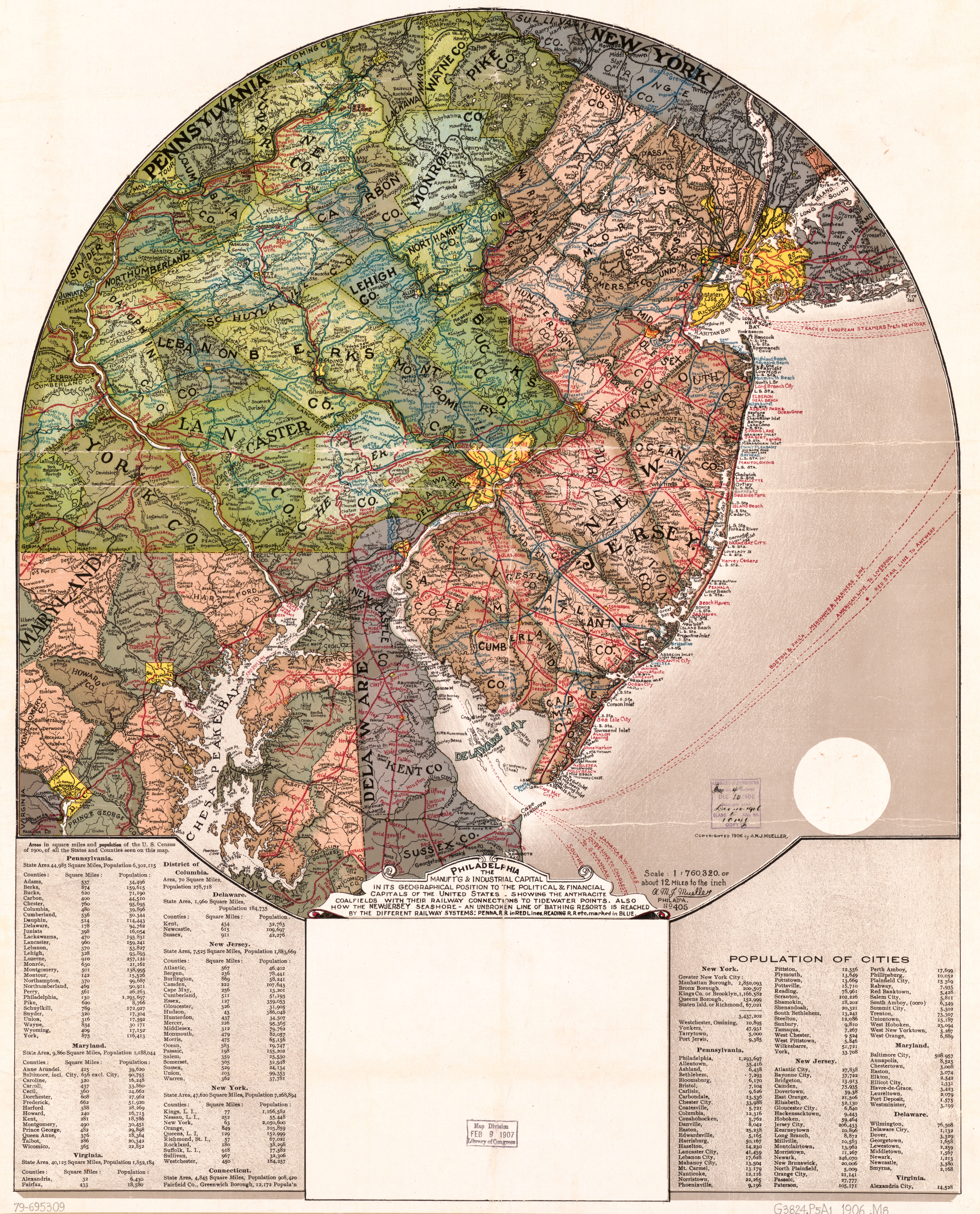
FULL TITLE Philadelphia, the manuft’g & industrial capital in its geographical position to the political & financial capitals of the United States : showing the anthracite coalfields with their railway connections to tidewater points, also how the New Jersey seashore, an unbroken line of bathing resorts, is reached by the different railway systems. Philadelphia: A. M. J. Mueller, 1906
DATE 1906
SOURCE Library of Congress
EXTENT A large circle with Philadelphia in the center, showing all of New Jersey, southeastern Pennsylvania, New York City and part of New York State, Baltimore and part of Maryland, part of Delaware, and a tiny bit of Connecticut. Size: 62 x 49 cm (about 24 x 20 inches). This may have been produced as a giveaway advertising item, with the blank space reserved for printing a company’s name and information. While Philadelphia may be the focus of this map, I can’t help noticing the larger yellow blob looming to the north: New York City, Philadelphia’s rival for commercial and industrial dominance.
WHY DO I LIKE THIS MAP? I had never seen this map but stumbled on it recently while looking for something else on the Library of Congress website. A. M. J. Mueller managed to include a whole lot of information on this map without making it seem crowded. There are streams and other bodies of water with their names, county names and boundaries, railroad and steamship lines, and even minor communities are identified. The labels are done in a freehand, almost folksy style but are still easy to read. In short, this map is both pretty from a distance and fascinating when you delve into all its details.
MORE FROM MUELLER Mueller also published excellent atlases of counties around Philadelphia, some of which you can find at the Greater Philadelphia Geohistory Network of the Athenaeum of Philadelphia.
OTHER PHILLY-CENTRIC MAPS Also available online are several other wonderful maps placing Philadelphia in the center:
- A Plan of the City of Philadelphia and Environs Surveyed by John Hills in the Summers of 1801, 2, 3, 4, 5,6, & 7. Engraved by William Kneass, and published in 1808. Hills’s circle, 9 miles around, cuts off some of the outlying areas of the city as it currently exists, but before the Act of Consolidation in 1854, Philadelphia was only the two square miles we now call Center City; the rest was the County of Philadelphia.
- Map of the Circuit of 10 Miles Around the City of Philadelphia, surveyed and drawn by J. C. Sidney and Dr. [Joshua] Ash, engraved by August Kollner, and published by Robert P. Smith in 1847.
- 12 Miles Around Philadelphia, published by R. L. Barnes in 1867.
- Scattergood’s Map of Sixteen Miles Around Philadelphia, published by Scattergood & Van Derveer in 1876. This version finally found the perfect circle to capture the entire consolidated city – one 16 miles in diameter, with City Hall in the center.