
This brief overview was written in 2005 as part of my research into Cobbs Creek for the PWD Office of Watersheds. During the course of this work, I gathered hundreds of historical images of the watershed. Many were taken from old atlases of Philadelphia, Delaware and Montgomery counties, housed at the Free Library of Philadelphia Map Collection. My map reproductions were made by shooting color slides of the library’s atlases, but in the years since then many of these books have been scanned and are now viewable online at www.philageohistory.org, or through the Free Library’s own digital catalog.
I appreciate the convenience of being able to do so much research at home, but I also miss handling these oversized volumes in person. I am in awe of the work that went into creating these atlases – from the surveyors who measured the land, the cartographers who took the surveyors’ field books and drew the maps, and the printers who created such beautiful, colorful artifacts. Books like these are rarely, if ever, made today.
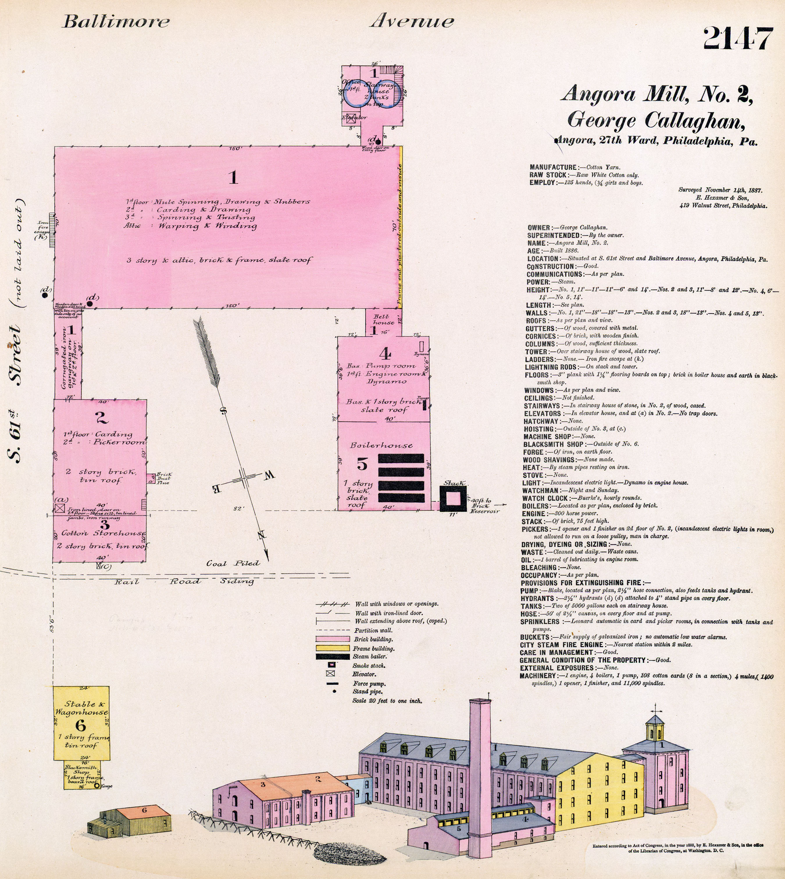
I have chosen to illustrate this essay with plates from another set of oversized volumes in the Free Library collection – the Hexamer General Surveys. These detailed plans of industrial establishments, numbering more than 2,000, provide a wealth of information, from the construction materials used to the products being made, the number of hands employed (including boys and girls), and the location of fire-suppression equipment. While the surveys do not show topography, they do show the streams beside which many factories were located, and the reservoirs and mill races that provided both water for industrial processes and a channel for carrying off wastes. They also give hints of topographic features with lables like “meadow, “farmland,” and “hill.”
I especially love the later surveys, which feature colorful isometric drawings of the factory complexes. Where I have been able to compare these drawings to factories still standing, or to photographs of factories now gone, they prove to be remarkably accurate. The Greater Philadelphia Geohistory Network of The Athenaeum of Philadelphia hosts the Hexamers surveys online, with an excellent index that I helped create. While there are many options for searching the survey listings, I have found that the best way is to open up the entire index and use the find feature on your broswer to do a keyword search.
Cobbs Creek is a major tributary of Darby Creek, and has several tributaries of its own, including Naylor’s Run, and the east and west branches of Indian Creek. Several other tributaries, including Thomas Run, were converted into combined sewers in the late 19th and early 20th century. The creek forms most of the western boundary of Philadelphia, and the watershed covers parts of the city and parts of Delaware and Montgomery counties.
The history of the Cobbs Creek watershed is typical of many similar watersheds on the borders of Philadelphia County – a progression from natural fields and woodlands inhabited only by native peoples, to an agricultural and industrial era fueled by the energy of European immigrants, which eventually gave way to population pressures as open lands were developed into densely-built residential neighborhoods.

Before the beginning of European exploration and immigration, the area was home to Native Americans, particularly the Lenni Lenape tribe. They used Cobbs Creek (which they knew as “Karakung”) and its surrounding tributaries and lands for fishing, hunting, transportation, and rudimentary agriculture.
Dutch, Swedish and finally the dominant English Quaker immigrants settled the area beginning in the mid-17th century. Marshes were diked or drained both for health reasons, and to provide dry ground for pastures or growing hay for sale. Streams were diverted into man-made millraces to provide power for a growing number of small mills.
These Europeans began what became the wholesale clearing of woodland in the watershed, both to open up farming and pasture lands and to provide lumber for buildings in the growing city of Philadelphia. By the mid-18th century, these these “plantations,” as farmsteads were then known, were probably the most common landscape feature in and around the City.
It is likely that the removal of forests led to increased runoff and stream flows during storms, and increased sedimentation and erosion. But the actual historical effects of these and other man-made changes in the watershed on the aquatic and terrestrial life are difficult to quantify.
The oldest mill in Philadelphia, built by the Swedish settlers on Cobbs Creek in 1642, stood just upstream from where Woodland Avenue now crosses the creek, and subsequent mills on this site used water power to grind flour into the early 20th century. By the 19th century there were dozens of water-powered mills along Cobbs Creek and its major tributaries, Naylor’s Run and Indian Creek.
Besides the usual saw, grist and snuff mills, in the early 1800s a thriving gunpowder manufacturing center was located along the creek, in Haverford Township. Keystone Paper Mill stood at the confluence of Indian Creek and Cobbs Creek, and near 63rd and Market, in Millbourne Borough, the Millbourne Flour Mill of the Sellers family stood for more than 100 years.

Numerous textile mills existed in the watershed, with clusters of factories in the Angora section of West Philadelphia (near 60th Street and Baltimore Avenue), the Cardington neighborhood of Upper Darby (where Marshall Road crosses the creek), and in the Haddington neighborhood of Philadelphia, where the east and west branches of Indian Creek joined (now Morris Park, at the intersection of 69th Street and Haverford and Lansdowne Avenues).
Water used in various industrial processes, such as paper-making and textile dyeing and bleaching, was dumped directly back into the creek, untreated, which certainly had an adverse affect on water quality and aquatic life.

The wholesale transformation of the watershed, from mostly open space with scattered villages and small industrial centers into a mostly-developed residential area, began in the later part of the 19th century. One factor in this change was the completion of the Mill Creek sewer in West Philadelphia.
Entering Philadelphia at 63rd Street and City Avenue, Mill Creek cut a diagonal five-mile valley through West Philadelphia before emptying into the Schuylkill River at 43rd Street. In some places 35 or 40 feet below the current street levels, the creek served as an impediment to development, which tended to stop at its eastern edge. Encapsulation of this creek in a combined sewer, begun in 1869 and completed about 1895, and the subsequent filling and leveling of the valley, allowed the grid of rowhouse development to continue unimpeded toward Cobbs Creek, the City’s western edge.
A second important factor in the watershed’s transformation was the construction of the Market-Frankford Elevated Railroad. Begun in 1906 and completed by 1908, this line allowed quick access into the city for suburban dwellers, and greatly spurred residential construction in the western parts of Philadelphia and eastern Delaware County. In 1932, a newspaper article stated that more than half of West Philadelphia’s 90,000 homes had been built after this project began. The same article noted that by that time Upper Darby’s population had mushroomed to 60,000, with much of that growth coming after 1920.
This rapid development contributed to the degradation of the stream quality in several ways. A number of Cobbs Creek tributaries were completely obliterated, the largest being Thomas Run, which once ran from about 53rd and Walnut streets to Cobbs Creek at about 60th Street. Today it runs only underground, in a combined sewer.
Thousands of feet of Naylor’s Run were channeled into underground culverts to facilitate commercial and residential development in the filled land above the pipes. A massive increase in impervious surfaces in the watershed meant that runoff was reaching the creek more quickly, leading to higher storm flows, increased erosion and scouring of the stream bed.
Furthermore, sewers from the new neighborhoods in the watershed emptied directly into the creek and its tributaries, polluting the water with raw sewage. By 1914 Philadelphia had constructed an interceptor sewer which kept wastes from within its boundaries from entering the creek, but it took decades more before communities in neighboring Delaware and Montgomery counties did the same.
By the 1930s, most of the mills had left the watershed, leaving abandoned buildings as the main reminder of the area’s once-thriving industrial heritage. Residential development continued to spread, with large sections of Overbrook Park in Philadelphia built up after World War II, and development continuing into Haverford and Lower Merion Townships in the 1950s and 1960s, although at a considerably lower density.
In more recent times, polluted stormwater runoff and inadequate drainage systems, leaking and inadequate septic tanks, lack of open space and adequate recreation, illegal dumping, and an array of other urban ills have also taken their toll on the quality of human and natural life in the watershed.
On the bright side, beginning in the mid-19th century, a number of cemetery companies began buying up large tracts of the watershed and establishing Mt. Moriah, Fernwood, Holy Cross, and Arlington cemeteries. As the farmsteads in the watershed, one by one, were transformed into residential neighborhoods, these cemeteries served to preserve hundreds of acres of open space by keeping them out of the hands of developers.
The creation of Cobbs Creek Park and Morris Park in Philadelphia, in the beginning of the 20th century, also managed to preserve hundreds of acres of open space, and saved both branches of Indian Creek from being completely obliterated and piped into underground sewers, as is shown on various planning maps of the era. And in the first decade of the 21st century, a small section of the west branch of Indian Creek that had been diverted into a sewer was daylighted and reconnected with the east branch above-ground.

Finally, plans for a Cobbs Creek Expressway up the Cobbs Creek valley (I-695), which would have begun at I-95 near Essington and connected with another expressway at Whitby Avenue in West Philadelphia, were finally killed in the mid-1970s, with the money diverted into mass transit projects.