This website is a safe haven for anyone afflicted with cartographilia.
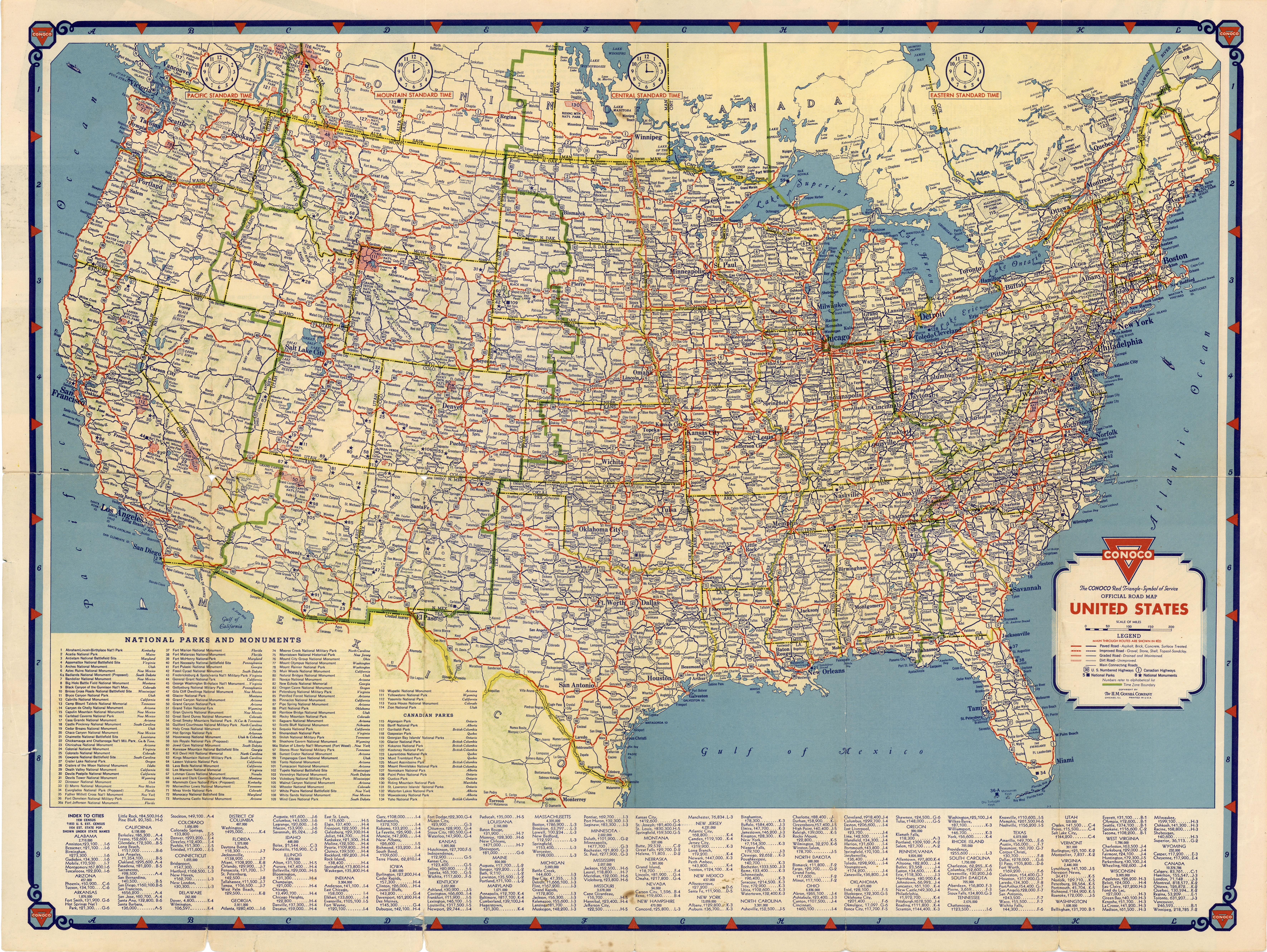
FULL TITLE Conoco Official Road Map [of the] United States. Copyright by The H. M. Gousha Company, Chicago, Ill.
SIZE 18 x 24 inches unfolded; 4 x 9 inches folded
DATE 1934
SOURCE Glove compartment of Adam Levine
WHY I LOVE THIS MAP (and all others): I have been a map geek for most of my life. On a family vacation the year I turned 12, my mother drove us through rural New England and I served as her navigator, using the folding state maps that every gas station chain would give you for free. (I was also the only one in my family, it seemed, who could properly refold those maps.) In 1982, when I was 24, I drove across the United States, trying to both see the country and run away from who I was. I never managed to leave me behind, but I saw plenty of sights in that three-month 6,000 mile journey.
I meandered from place to place, hopping between friends and family members and cheap hotels and youth hostels and occasional tent camping in national parks and monuments. I mostly avoided the interstates, finding my way along smaller state roads using a cache of detailed road maps. My muse and inspiration (and my occasional guide, where it was still accurate) was a Conoco Travel Club folding road map from 1934 that covered the entire United States (see above). It showed nothing but state roads, since it predated the Interstate Highway System by about 20 years.
The first thing I still do when I got to a new place is open up a paper map and try to get a feel for the lay of the land, for the geographical relationships between the place I am staying and the places I want to see. I used to love the challenge of finding my way somewhere I had never been. I still have a collection of paper maps and street atlases that I can’t bear to part with, but I rarely visit these old friends anymore. GPS apps on the phone and on my computer have taken their place, and I feel like I’m stupider for their existence. The yammering computer voice now guides me every place I’ve never been. Like most people, even when I know exactly how to get somewhere, I still ask GPS if my way is the best way, to make sure I don’t run into any unexpected traffic.
Maybe that’s not stupid—has anyone ever enjoyed sitting in a traffic jam?—but I feel like I am losing my ability to find my own way. Before GPS I sometimes took a wrong turn, of course, but I always got back on track and eventually reached my destination. Getting lost was part of the learning process. Now, even if I take a wrong turn the app automatically recalculates my route, and I never learn a thing.
INTRODUCING… All of which is a long introduction to this new regular feature on WaterHistoryPHL. On occasional Mondays I will share one or a few of my favorite maps. Most will be from this region, and many will be a hundred years old at least. Some might be familiar to you, and others may surprise you. All of them will be presented at a resolution that will allow you to fully explore all their details. And I hope that all of them will both enlighten and delight you.
Use the feedback link below to share any suggestions for maps that I might feature on future Mondays.