SEE UPDATED INFORMATION FROM A WHPHL READER AT THE BOTTOM OF THE PAGE

Yesterday I joined a tour of the Schuylkill Navigation towpath and railroad bridges in the vicinity of Philadelphia’s Manayunk neighborhood. The tour was led by Sandy Sorlien, a historian and photographer who works for the Philadelphia Water Department and is the author of Inland, which features her beautiful photographs of remnants of the navigation system. We met at the parking lot of the movie theater on Main Street in Manayunk, and from there we crossed the river on the pedestrian path of the hundred-year-old iron truss Pencoyd Bridge.

After examining the few extant remnants of the old Pencoyd Iron Works property (which once stretched for about a mile along the river in Lower Merion Township, and has now been redeveloped as a hotel and residences) we followed the troute of the old canal towpath, which is now paved and part of the Cynwyd Heritage Trail system. We then cut off the main trail, went under the Schuylkill Expressway and railroad tracks, and climbed an old road through a steep valley to another part of the Heritage Trail which curves between Westminster and West Laurel Hill cemeteries. The trail crosses the curving concrete Manayunk Bridge, which once carried a branch of the Pennsylvania Railroad from Lower Merion to Manayunk and now carries pedestrians and people on a variety of human-powered locomotion–including, if one believes one of the signs on the trail, pogo sticks. . At the Philadelphia end of the bridge we met Tom Watson, a Manayunk neighbor who helps maintain a garden, informal music venue, and a kids’ play station where the PRR’s Manayunk Railroad Station once stood. We then made our way back to our cars along Main Street and the Manayunk Canal towpath.
It was a beautiful day, and the views up and down the river from the high bridge were spectacular. The Lower Merion Township Planning Department deserves kudos for spearheading this project, which turned a railroad right of way abandoned by SEPTA into a much-beloved public space.
This morning, while going through my files looking for illustrations for this post, I came across a panoramic view of Manayunk:

I also found these, in a collection that the late PWD historian Jane Mork Gibson had obtained from John Kiker. Several of the Kiker photos were matched pairs which did not quite overlap but were clearly meant to create panoramic views.

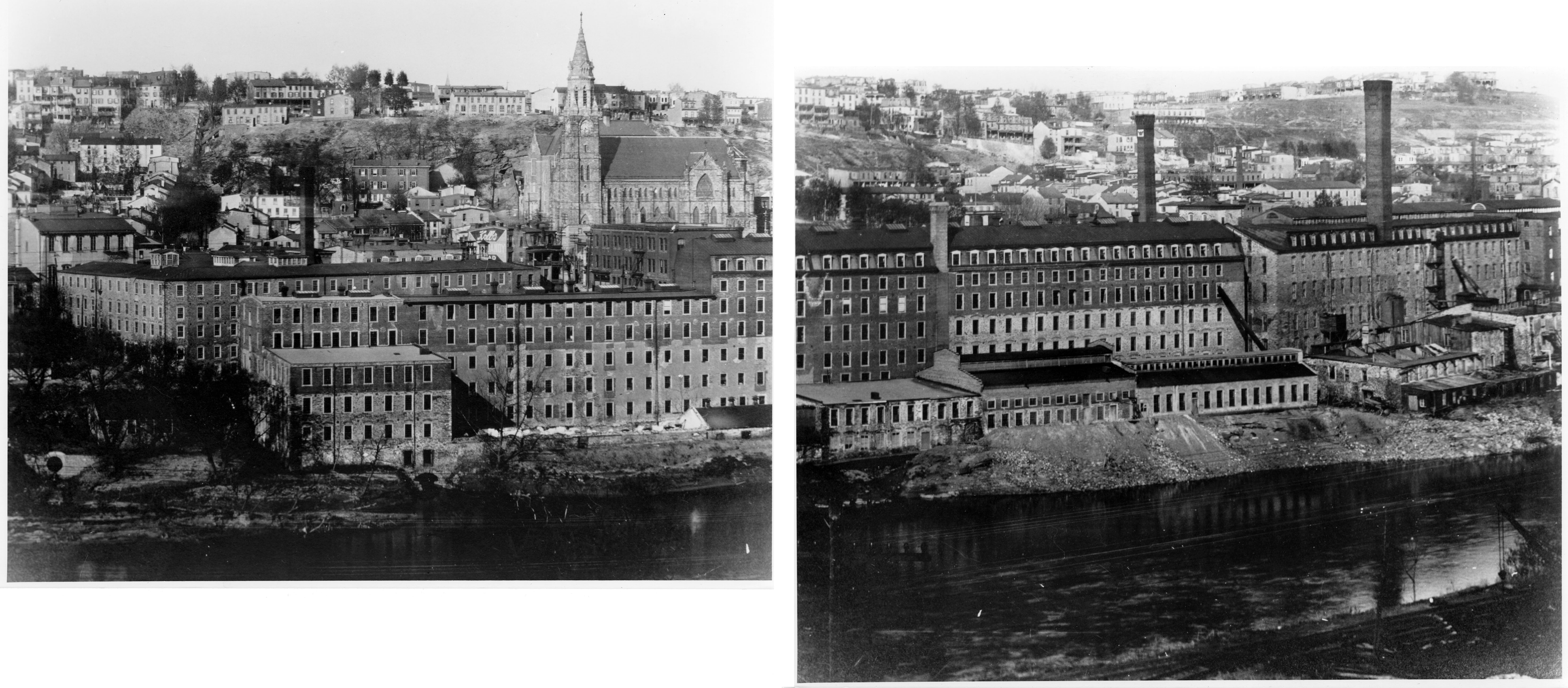
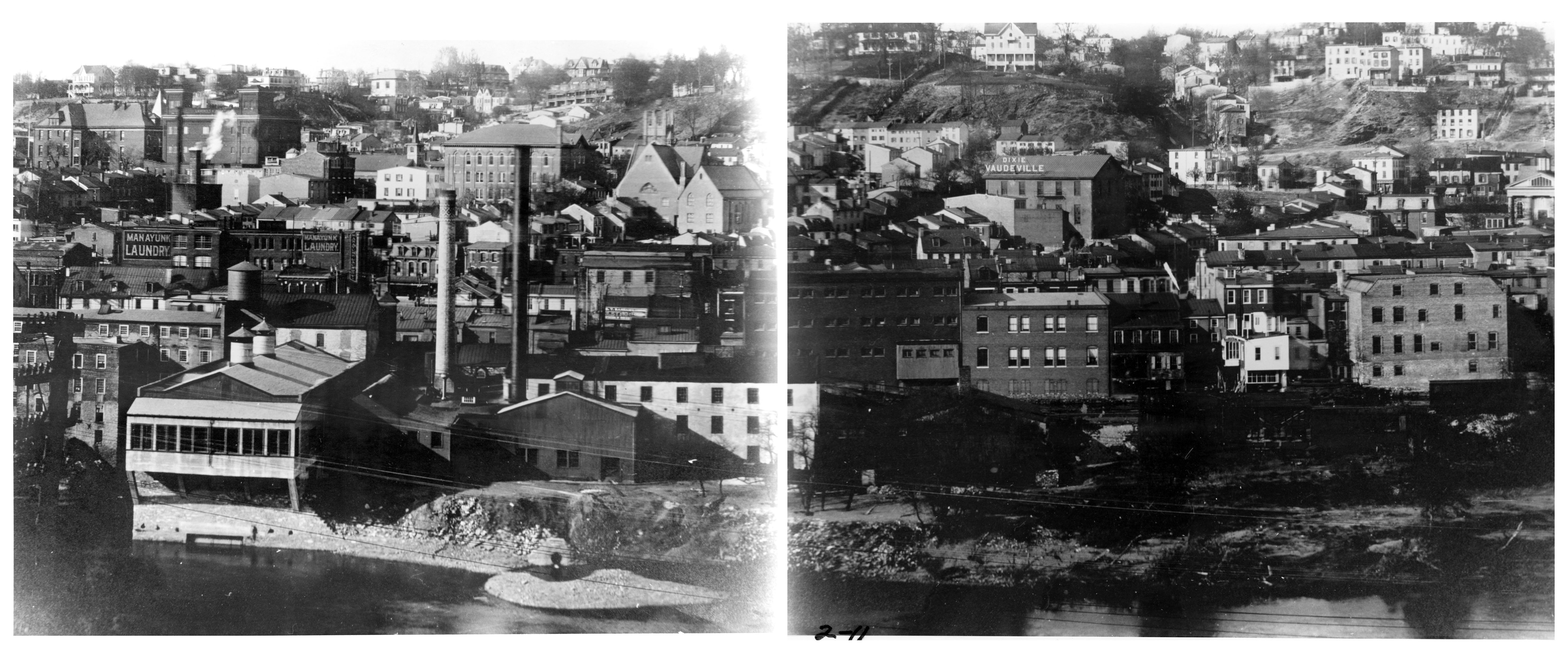
Finally, I found three photograph that is part of the Walter Pertuch Collection of glass plates and lantern slides, used by permission of the Fairmount Park Historic Resource Archives, Philadelphia Parks and Recreation. The best of these was a panorama made by joining two images. It can be seen at the top of this post, and I’ve included the two separate images below.


MORE INFORMATION ON THE PICTURES ABOVE FROM HARRY GARFORTH:
Several rail transportation facilities are evident. The dominant railroad shown is the Pennsylvania Railroad (PRR) which built the “S” Bridge in 1884. The bridge was part of the PRR’s attempt to strike back at the Philadelphia & Reading Railroad (P&R) in their competitive battle to dominate rail traffic in Pennsylvania and New Jersey. The PRR Schuylkill Branch, which crosses the bridge, extended from 52nd Street, through Lower Merion, across the river and paralleled the P&R some 90 miles into the Anthracite coal fields in upstate Pennsylvania. Under the “S” Bridge is a roller coaster looking wooden trestle built to serve Pencoyd Iron Works off the “S” Bridge which towered 180 feet above the valley. A switch back was necessary to overcome the gradient. Officials of the Pencoyd Iron Works and the PRR were related, so the trestle allowed the PRR to capture some of the Pencoyd shipments.
On the Manayunk side, the PRR Manayunk passenger station can be seen located at Centre & High Streets with long walkways down to the central business district and towards Leverington Avenue. The late entry of the PRR into Manayunk and its placement some 180’ above Main Street required considerable walking. The P&R Manayunk station was located one block off Main Street at Gay Street. The PRR also had a freight station on Canton Street which escaped capture in photographs. It is shown with a high level platform for unloading or loading material into box cars. Between the PRR passenger and freight stations a six span girder bridge can be seen carrying the tracks above Leverington Avenue. Both this bridge and the “S” Bridge were replaced in 1917 with concrete structure to improve strength for larger locomotives and geometry, allowing higher train speeds.
The P&R Manayunk freight complex is also shown with twenty plus freight cars in the multi-track yard which was located on the north side of the main tracks until the railroad was elevated over Cresson Street in 1930. The steam engine shifting cars is an older locomotive with a rear cab. The P&R later adopted a Camelback design for its steam locomotives to burn anthracite coal more effectively in the fire box with a larger grate area. The wide fire box required moving the cab forward over the boiler creating a camelback look. The mix of freight cars shows various types of commodities were handled with most car being box cars capable of modification for shipping various products. Not seen in great numbers are coal hoppers which were used to deliver anthracite to multiple dealers in the area. Most had spurs into their facilities to supply the home heating market in the dense housing surrounding the tracks.
In most of these old photographs, the industries shown were in their heyday. Now little manufacturing remains in Manayunk, and those factory buildings that have not been demolished have been transformed into residential or office space. But when viewed from the height of the Manayunk Bridge, it is easier to imagine that Manayunk’s past is still present. All that I need to add to my mind’s eye is the coal smoke billowing from the factories, as shown in this 1907 view from the Library of Congress.